
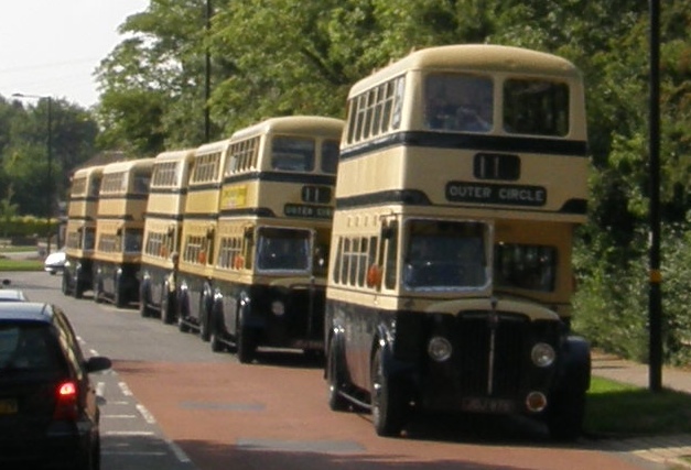
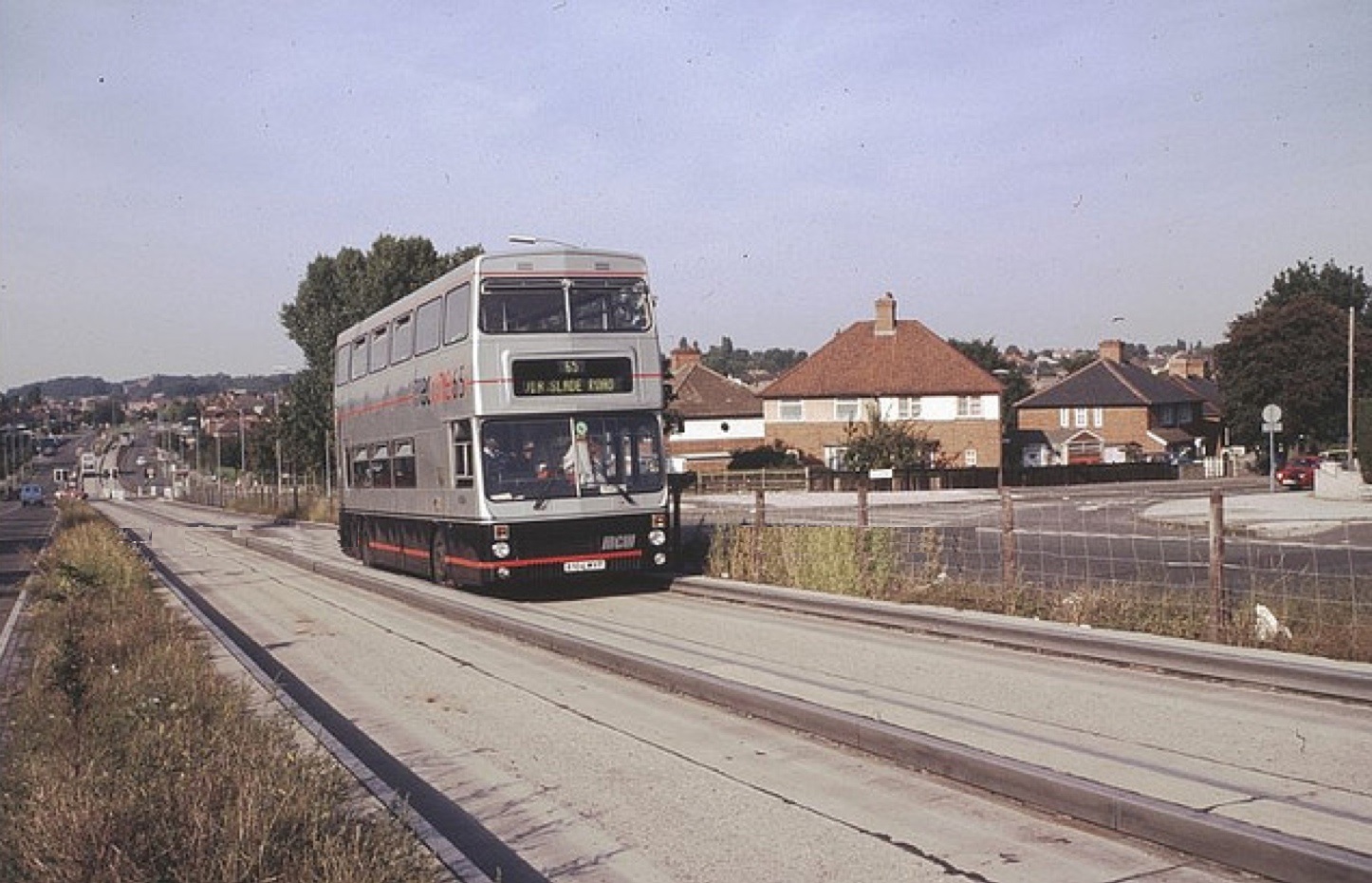
A Line of BCT buses at Sarehole Mill on 26th Aug 2013
So here’s the tour. Use this to conduct your own guided tour of the Outer Circle. You’ll have to get one of the current 11A Buses, and start at Sarehole Mill (there’s a free car park at the mill!).
OK – here’s the plan. You decide, because you are a Brummie (or an adopted Brummie and can’t drag yourself away) to find out more about the outer reaches of the Second City. Then you ask a mate to join you – you’ll find you may need one!
You then choose your mode of transport. Ideally it would be a 1950s Birmingham City Transport double deck bus – but getting one can prove to be a tad expensive, even to hire for a few hours. So you can use your own car, or your mate’s. This is where the need for a companion comes in – someone has to drive whilst you soak up the history. Finally the most economic and “21st century practical” mode of transport would be a modern bus. The fare (in 2016) would be £2.30 (and get your mate to pay his own fare)! But of course if you regularly rode on a Birmingham City Transport double deck bus in the 1950s, then you can travel today for free with a pass!
The bus that you need to catch is the 11A preferably at Sarehole Mill on the border of Hall Green and Moseley. This will take you on the Outer Circle in an Anti-clockwise direction. Why Anti-clockwise? More of that later.
Next you need a guide to your journey and this one will tell you virtually all you need to know about the history of the Outer Circle. Your own Guided Tour. You can also find a copy of our MAP of the Outer Circle to print out or follow as you go round. Click HERE to find the map.
The tour was compiled by OuterCircleBus.com and first created for the date of 11-11-11 – a numerical coincidence that could not be ignored. In 2011 I celebrated that date by hiring a 1950s Birmingham City Transport double deck bus and filling it with people eager to hear about their city. We went round the Outer Circle in an Anti-clockwise direction for a simple reason – it was my “happy direction”. In the 1960s I lived in Hall Green (near to Sarehole Mill) and my girlfriend lived in Fox Hollies Road. I went to school in Bournville. So the journeys riding on the bus home from school and visiting my girlfriend both took place in an anti-clockwise direction – my happy direction. By the way, that girlfriend is now my wife.
So let’s set off – 11am is a good time – the roads are not too busy and we’ve even planned in a break for a cuppa or a bite to eat half way round.
~~~
So here we go! ………….
Here we go round ……The Outer Circle
Our starting point for our circumnavigation of Birmingham’s Outer Circle Bus route is Sarehole Mill. The current mill building dates from 1773 although it seems that there was a mill on this site from 1542. The mill on our left was closed in 1919 and restored in the 1960s after a public appeal against its demolition. The chimney by the mill stands testament to the fact that it was powered by a steam engine to compensate for the lack of water at times. The mill was originally used for grinding corn, but as the industrial revolution encroached on the area it was used for a number of metalworking purposes. Sarehole Mill was one of 16 mills on the River Cole as it ran though southeast Birmingham to where it joins the River Blythe, then the Tame near Coleshill. The mill was powered by the Cole and a tributary, Coldbath Brook that ran from the top of Swanshust Lane. The River Cole is 26 miles long, coincidentally the same length as the Outer Circle Bus route.
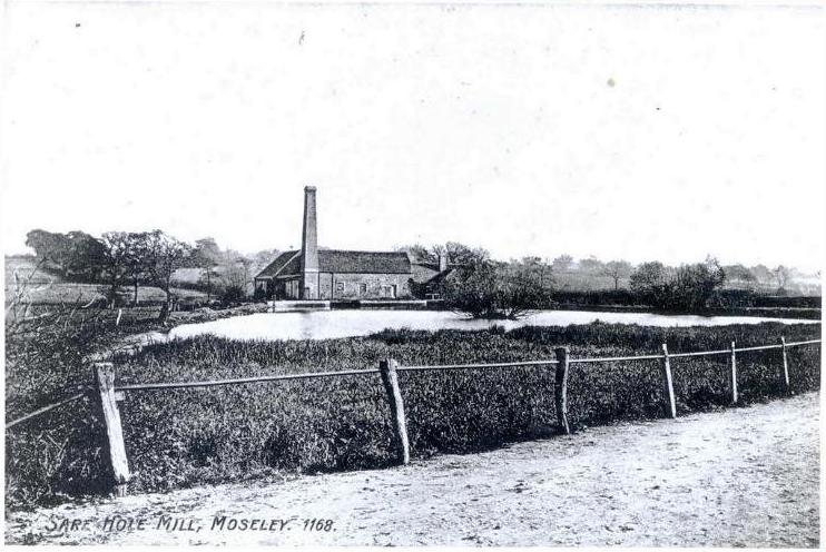 |
A view of Sarehole Mill taken across the millpond from Wake Green Road in 1905. What is most noticeable is how few trees there are! |
The first roundabout is at the junction with Sarehole Road where one would have found, about half a mile away to the left the Aldis factory. This is where the famous Aldis lamps, used for signalling Morse code between ships, were made. The factory was built on a Greenfield site at the start of the First World War in 1914 and later became part of the Bell & Howell Company. I have been reliably informed that Aldis tested and focussed their lamps by shining them at the tower on Moseley School, about 900 yards away. The Aldis name is commemorated in the name of the cul-de-sac of houses built there in the last decade.
At the top of Cole Bank Road we cross Southam Road and to the left about 200 yards along here is the house where comedian Tony Hancock was born and lived until he was three. A statue of Tony Hancock was erected in 1996 in Priory Circus in Birmingham.
After Southam Road we cross what was originally the North Warwickshire Railway line to Stratford-upon-Avon. The railway went on to Cheltenham and the southern part is now the Gloucestershire & Warwickshire Railway. After being built the railway was absorbed into the Great Western Railway and is now on a main commuter route to Birmingham Moor Street. You can still enjoy a ride on a steam train along this line on Sundays throughout the summer months.
We are approaching the Stratford Road, the A34, which was part of the main route from Birmingham to the port of Southampton and consequently became one of the areas busiest highways before the construction of the M40.
Cole Bank Road originally met the Stratford Road at a junction just by the black & white house on the left. This meant that an Outer Circle bus heading in our direction had to make a right turn onto Stratford Road before turning left into School Road. The junction was straightened out to become as we know it now in the 1950s to ease congestion.
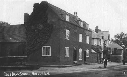
The “Tyre Sales” premises on our right stands on the corner of School Road where at one time you would have found the building that was occupied by the ATCO lawnmower company. For many years before and after the Second World War this location was known to bus travellers as the ATCO. Previously this was the site of Cole Bank School that opened in 1791 and gave School Road its name.
Cole Bank School, once situated on the corner of Stratford Road and School Road. Next door is the pub once known as the Horse Shoe Tavern, now the Horseshoe which apparently offers “north Indian and Modern British cuisine”. |
 |
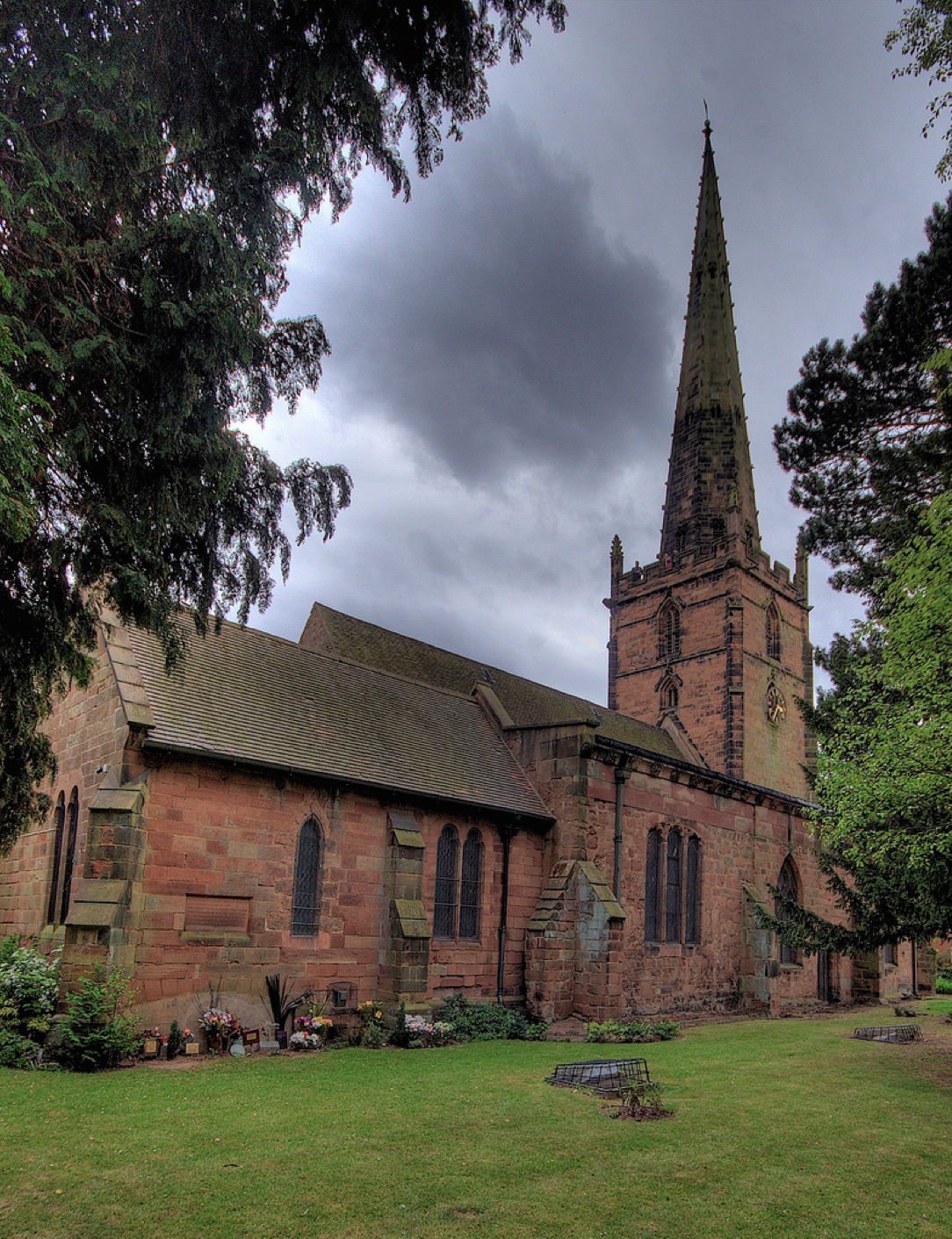
On our right just before we turn off School Road is Hall Green Parish Church – the Church of the Ascension. It was originally known as Job Marston’s Chapel after a local landowner who contributed two thousand pounds towards its construction. It was consecrated in 1704. The original building and additions in the 1860s are in the English Baroque style, unusual in a Church building and it became grade II* listed in Nineteen-Fifty-Two.
On the diagonally opposite corner of the junction from the church is the site of Hall Green Hall, or Hawe Hall as it was originally known. This was a timber-framed house and it was extended in Tudor times and again in the 18th century. Last occupied in 1935, the hall was sold and demolished for the construction of the Charles Lane Almshouses that stand there now.
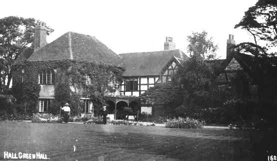
Hall Green Hall – Once known as Hawe Hall. Hawe Green took its name from the medieval family whose moated hall stood at the junction of School Road and Fox Hollies Road near the green or common pasture. The word ‘haw’ probably derives from the medieval word haga meaning ‘hedge, enclosure, or enclosed land’. The family had taken their surname from this commonplace name, but whether that was here or elsewhere is not known.
We now turn into Fox Hollies Road, the first of the suburban dual carriageways on our route that were planned by the city between the wars to give easy access around the city. The plans were never completed due to the interruption of the Second World War, and we will see that there are places on our route where housing was built to allow a dual carriageway that was never completed.
The name Fox Hollies comes from the time when the Fox family bought the farm belonging to the atte Holies in the 15th century, and this became the name for the whole of this area between Hall Green and Acocks Green.
We are heading towards the junction with York Road, on the left. If you went down York Road for about a third of a mile you would find, by the railway, the site of the Vellocette factory. Motorcycles, including the famous police “noddy” bikes, were manufactured here between 1926 and 1971.
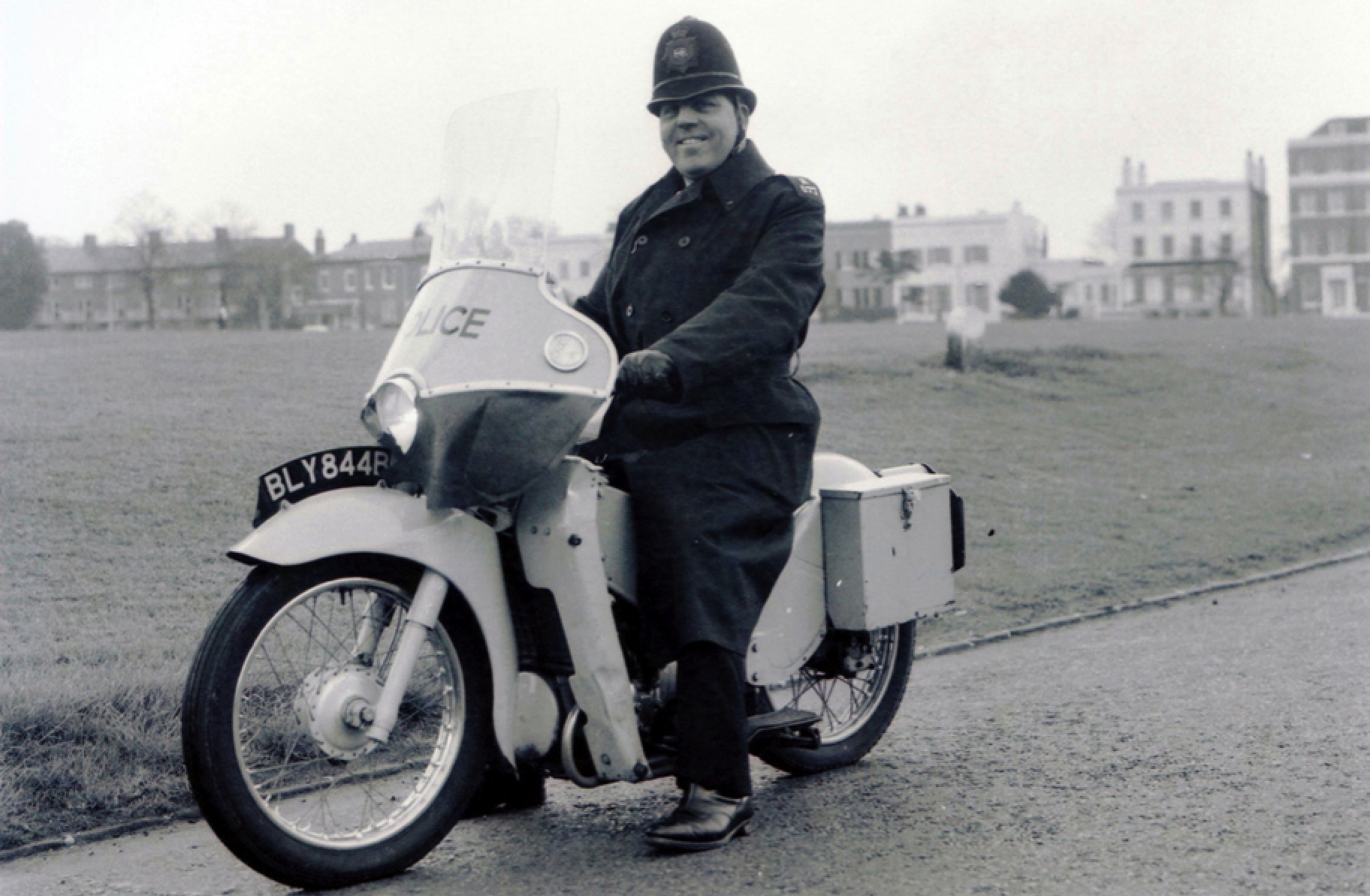
The LE became Velocette’s best selling model. It saw widespread adoption by police forces for urban patrol. At the time policemen on foot patrol were required to salute sergeants and inspectors. With the introduction of the LE this became dangerous, requiring the officer to take his hand off the handle bars, and so the rider was allowed to show respect with a smart nod. It has been suggested that this is how the LE became known as “Noddy Bikes”. However, Noddy (the popular cartoon character created by Enid Blyton) who famously had frequent run-ins with the Policeman Mr Plod, is also credited with being the origin.
After we go past the York Pub, look to the left you will see two stone gate pillars by the next bus stop, which is all that remain of Fox Hollies Hall. The son of industrialist Zaccheus Walker built the hall in 1869 to a design by council house architect Yeoville Thomason. His grandson, Lieutenant-Colonel Zaccheus Walker owned the hall up to his death in 1930 when it was passed to the city Parks Department and it then fell into disrepair. The hall was demolished in 1937. Everyone in the area knew the derelict land as Colonel Walker’s, until the three tower blocks were built and the remaining land made into a park in 1965.
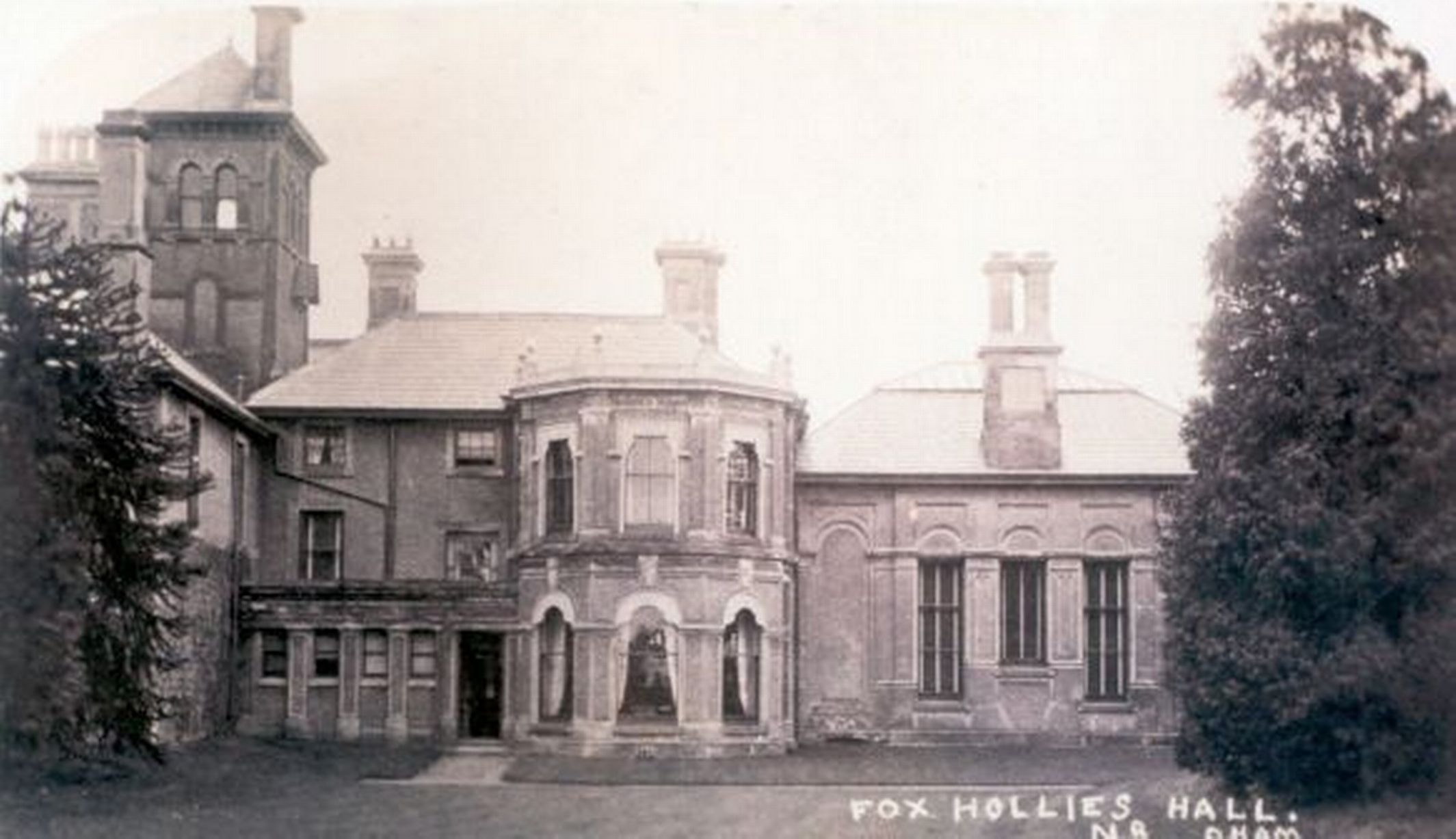
Fox Hollies Hall c1900
Look to the left as we go round the next roundabout at the junction of Olton Boulevard and you can see in the distance Shaftsmoor Lane. If you were to turn left along there and look to the right you would be able to see the house where Bobby Davies lived as a child. “Who” you might ask “is Bobby Davies?”- Well the answer lies in a funky moped and a nutter on the bus – it is Acocks Green’s own folk hero Jasper Carrot.
As we travel along the final part of Fox Hollies Road, to the left you can see Acocks Green Bus Garage, which was opened in 1928 and survived the rationalisation of the bus garages within the city when the transport undertaking was transferred to the West Midlands PTE.
The earliest known reference to Acocks Green is in the Yardley Parish Register of 1604, but the name derives from the Acock family who built a large house in the area in 1370. This was sited about half a mile down the Warwick Road from Acocks Green Village at the junction of Woodcock Lane. Although the Acock family left the area in the 18th century the house remained. It was demolished in the 1950s and replaced with blocks of flats.
At the end of Westley Road on the right is the 10-pin bowling alley which was converted from The Warwick cinema in the 1960s. Next door is the premises of a car tyre dealer, which was once a “pumpless” petrol station. This was a Japanese invention where the pump nozzles were suspended from the ceiling of the canopy and lowered down to a point just above the car roof where the attendant would pull it down the rest of the way to fill the car. What seemed like a good idea never caught on and there were very few of these in the UK. This one closed in the early 1970s.
Acocks Green Village became the centre of the area in the late 19th century, and trams arrived here in 1922. The road layout as we know it now was designed in 1932 and the tram terminus was incorporated into the central traffic island.
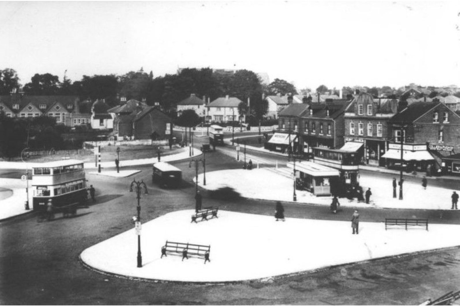
Acocks Green Village in 1932 showing the tram terminus in the centre of the traffic roundabout.
The library building behind us to the right next to what was The New Inns pub was opened in 1932 and was at the time the largest in the city. The building is now Grade A listed.
After the Village, we find another point on the Outer Circle where the number 11 does a double turn, although this time the turn off Westley Road, along Warwick Road into Dudley Park Road was never given the “straightening out” treatment that happened at Hall Green.
With the arrival of the Great Western Railway in Acocks Green in 1852 many large houses were built along here and in the nearby roads as business people from Birmingham moved out to Acocks Green with its new rapid transport link to the city centre. We will soon cross over the station bridge where at one time the railway had two fast lines for expresses and two for the local trains that served Birmingham and Solihull.
The railway line through here from Paddington to Birmingham became very busy in the 1960s when the West Coast (Euston) line was being electrified. Then it was closed down as a route to London and Snow Hill Station was demolished. Now Chiltern Railways who have run trains from Snow Hill to Marylebone since 1996 are running trains that take just 90 minutes to get from the newly restored Moor Street Station to London.
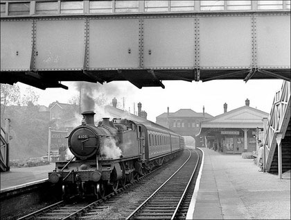
Acocks Green Station on 25 May 1957 with GWR 2-6-2T 4108 hauling a local train from Moor Street to Leamington Spa.
As we cross the railway, to the left is Acocks Green Baptist Church, which is Grade II, listed. But next to it on the corner of Alexander Road is the Arts & Crafts style Glynn Edwards Hall, which could be demolished after plans were submitted for a new community hall to be built in its place. It seems that due to a council cock-up the hall, built in 1924, was not listed correctly when it was given grade A protection. This is an on-going saga with residents & conservationists wanting to save the building, whilst the developers still have the bulldozers on standby!
Glynn Edwards Hall, Acocks Green still standing in September 2015.
In the 1920s after Acocks Green was absorbed into the city, a great deal of municipal housing was built in the area. Apparently the better-off that were living here started moving out and the area was given the nickname “Snob’s Green”.
As we leave the rows of terraced houses on the left behind us we cross the Grand Union Canal which was the main link between Birmingham and London in the canal network. To the left the canal would take us through Tyseley and Small Heath skirting round the east side of the city centre to reach Gas Street Basin. To the right the canal goes through Olton on its way to Knowle and Hatton with their famous flights of locks on its way down to London. We always say “down” to London in Birmingham, true on a number of levels!!
After going over the canal bridge we find that Yardley Cemetery is on our right. An 8 acre cemetery was opened here in 1883 to relieve the churchyard of Yardley Parish Church. On the extension of Birmingham’s boundary in 1911, the cemetery was taken over by Birmingham Corporation. The cemetery is now some 64 acres, with the last extension occurring in Nineteen-Twenty-One. Although the cemetery served the local community well, interest in cremation was growing, so in 1952 the City Council adapted one of the chapels for cremation purposes.
We are now approaching what will be forever known as The Swan, although there is no longer a pub with that name here. The first known “Swan” inn was recorded in 1605 sited on our left before the junction. Then a much larger new pub in a Tudor style was built in 1898 behind the old one, which was then demolished. This is probably “The Swan” that most people over the age of 60 will remember.
 |
The Swan at Yardley in the 1950s. |
This was itself demolished and a new “Swan” was built in a contemporary style when the Coventry Road underpass was constructed in 1967. The Swan then boasted that it had the longest bar in Europe and was the largest pub in the UK.
This building lasted less than 30 years when it was replaced by the office block, which now stands on the site. The style of this building has tried to recapture some of the appearance of the 1898 Swan.
As we go round the junction we are crossing the A45 Coventry Road. In the early post war years of the British motor industry’s heyday this road was a major artery between the motor manufacturing centres of Birmingham & Coventry and the constant stream of trucks carrying components and completed cars allegedly made it the busiest road in the UK if not Europe.
Anyone who has not driven around the Swan since the beginning of 2011 will recall that previously the Outer Circle went straight along the very narrow Church Road lined with tiny shops and terraced houses before it opened out into one of the familiar dual carriageways. That has all changed and it seems that the power of the mighty supermarkets has re-planned this part of the Outer Circle bus route forever. Tesco has now opened a supermarket to our right and Church Road has been diverted around the car park, which has been built on what was parkland. In 2012 after about 7 years of legal wrangling the 1960s Swan Shopping Centre, which was originally named the Tivoli Centre after the 1927 cinema that stood near the corner of Coventry Road, was demolished leaving the original residential tower block above the new store. Hardings bakery stood next to the cinema on the corner to our right.
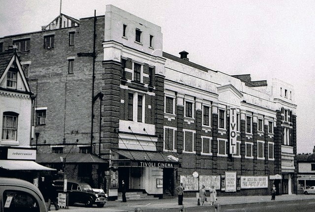
The Tivoli Cinema on Coventry Road opposite the Swan Yardley. It opened on 17th October 1927 with Rudolph Valentino & Gloria Swanson in “Beyond the Rocks”. The exterior of the building was designed by architect Archibald Hurley Robinson while the remainder of the building was by architectural firm Satchwell & Roberts. Seating was provided in stalls and circle levels, and the auditorium ran parallel to Coventry Road. The Tivoli Cinema was closed on 1st July 1961 with Bob Hope in “The Facts of Life”.
The original shopping centre in Yardley was here ahead of us at what is now known as the Yew Tree. The original yew tree stood outside where the Co-op pharmacy is on the left and was relocated to the centre of the traffic roundabout. It seems that this was damaged during road works and a new tree has now been planted there.
The original Yew Tree pub was built in 1925 in the grounds of Yardley House on Yew Tree Lane. Yardley House had belonged to prominent local families such as the Minshulls and the Flavells, but in 1919 the Flavells sold the house to the brewers Mitchells & Butlers, who built the pub and then demolished Yardley House in 1930. The Yew Tree was closed in 2000 as it was believed to be a magnet for crime. The building was subsequently destroyed by fire after an arson attack – a recurring theme on our tour. As we turn into Stoney Lane a new pub called the Clumsy Swan with a Co-op supermarket behind it stands on the site of The Yew Tree.
Further along Stoney Lane we will come to the junction of Blakesley Road and off to the left is the Grade 2 listed Blakesley Hall, which was built in 1590 by Richard Smalbroke, a member of one of Birmingham’s leading merchant families. More than 400 years later Blakesley is still a haven; secluded from the avenues of modern houses that lie beyond its gates. Admission charges apply to the Hall but the gardens, grounds and visitor facilities are free. There is free admission to the entire site on the first Sunday in every month during the open season.
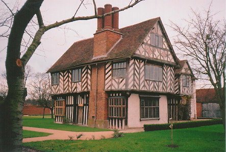
Blakesley Hall built by Richard Smalbrooke. He was a hardware merchant in Birmingham and Smallbrook Street (now Queensway) was named after him. He had family connections with the Colmores & Greswolds and owned much land in Yardley. The Merry family, a local paint and varnish manufacturer were the last of a long line of families to occupy the hall. Blakesley Hall then became a museum in 1935. An adjacent barn (Grade II listed) to the east of the hall has been renovated and provides space for exhibitions and functions.
To the right Blakesley Road would take us to the area known as “Old Yardley”. This was granted conservation area status in 1969, becoming the first in Birmingham. At the centre of this is St Edburgha’s, Yardley’s parish church, which dates back to the 13th century. Next to it is The Old Grammar School, which was in use from the 16th century to 1908. The spire of the church can be seen over the tops of the houses on the right.
St Edburgha’s church in Yardley. The church had six bells by 1902. The sixth bell had been produced by James Barwell of Birmingham, who also produced new bearings for all the bells. At the same time, the oak frame within the spire was repaired.
In 1949, it was discovered that the church tower had become infested with death watch beetles resulting in problems with ringing the bells. On 1 May 1949, the bells stopped ringing to allow work to begin on repairing the frame and recast the bells. The new ring of bells was dedicated by Michael Parker, the Archdeacon of Aston in September 1950.
As we cross Bordesley Green East the Outer Circle becomes Station Road, and along here on the right we see a number of houses which pre-date the 1930s and stand on the building line of the original road whilst those built between the wars lie much further back to allow room for one of the planned dual carriageways that was never completed.
Further along on the right opposite the shops is Stechford Cascades. This was originally built in 1961 and rumour has it that it was designed and constructed as the first Olympic size swimming pool in Birmingham, but between drawing board and construction the size of Olympic pools was changed from imperial to metric, so the new pool did not meet the international criteria.
After the shops we will pass over Stechford Railway station. This was built in 1844 by the London & Birmingham Railway and it lies three & a half miles from the city centre. Stechford Station was originally served by a wooden booking office built on the bridge, but it is now accessed from Victoria Road, which is on the left after the shops.
The railway line here is now part of the West Coast main line with Virgin’s Pendilinos whisking travellers between London & Birmingham four times an hour. The line was electrified in the 1960s and Stechford was the scene of an accident in February 1967 when an electric passenger train from Manchester to Coventry hit the locomotive of a goods train. Nine people lost their lives and 16 more were injured.
![Panoramic view of the approaches on the Coventry side of Stechford station with the down sidings on the right as seen on 7th September 1957. Amateur photographer Dennis Norton is standing on Station Road bridge with Hill House bridge in the distance. Stechford No 1 Signal Box is seen on the left. On the right is the “hump” used to 'fly shunt' wagons in to the down sidings. [Photo by DJ Norton]](https://outercirclebus.com/wp-content/uploads/2015/01/stechford-station-panoramic-view-of-the-station-approaches-on-the-coventry-side-1957-dj-norton.jpg)
Panoramic view of the approaches on the Coventry side of Stechford station with the down sidings on the right as seen on 7th September 1957. Amateur photographer Dennis Norton is standing on Station Road bridge with Hill House bridge in the distance. Stechford No 1 Signal Box is seen on the left. On the right is the “hump” used to ‘fly shunt’ wagons in to the down sidings. [Photo by DJ Norton]
On the right at the end of Flaxley Road is the site of the Bulls Head pub that was later called the Manor Tavern. This was demolished in 2000. The site of the pub is identified by the original post & frame that held the pub sign and it is now being used as a tyre depot, or is it a car wash? Next to it is land once used by fairground operators as an over-wintering site.
We now cross the River Cole for the second time and the area both sides of the river is a flood plain which has been designated as green belt. The name Stechford may have been introduced by the railway in 1844. There is reference to a ford over the river in 1249 named after the Stych which is a tributary of the Cole. Hence Stych-Ford.
The River Cole valley is known as the Kingfisher Country Park and along the river kingfishers and herons are a common sight, feeding on fish in the river. Water voles and mink are both associated with the river and, more recently, otters have been recorded at the lower reaches of the Cole.
We now travel up Stechford Lane to the Fox & Goose – at long last another bit of dual carriageway that was actually completed.
Look out for the Aldi supermarket on the right at the top of the hill, which stands on the site of the magnificent 1,500 seat Beaufort Cinema that opened in 1929. The Beaufort apparently boasted one of the finest cinema organs in the country, a Compton with 2 manuals and 8 ranks that was moved in 1937 to EMI’s Abbey Road studios in London.

The Beaufort Cinema just 2 years after opening. The Beaufort had a magnificent Tudor style interior and was closed on 19th August 1978 with Doug McClure in “Warlords of Atlantis” and Terence Hill in “Watch Out We’re Mad”. There were hopes that the cinema could be designated a ‘Listed’ building, but the powers that be at that time deemed it’s interior as fake, and not real Tudor, and listing was refused.
At the cross roads on the left is the Fox & Goose pub, which gave the junction with Washwood Heath Road & Coleshill Road its name. There was an inn here known as the Golden Cross in 1680 and the OS map of 1887 shows the building as the Fox & Goose. The pub was rebuilt in a Tudor style after 1905 at a time when this location still lay well beyond the urban area of Birmingham.
About two miles to the east are Castle Bromwich Hall Gardens. This unique example of an English Baroque Garden is being restored as near as possible to the period 1680 to 1760 by Castle Bromwich Hall and Gardens Trust. The 10 acre grade II* listed Walled Garden contains over 600 species of plants from the period and is a rare example of formal English garden design. The house was built in 1599 by Sir Edward Devereux and extended by Sir John Bridgeman about 100 years later. The Gardens were developed by several generations of the Bridgeman Family (later to become the Earls of Bradford) but they fell into decline during the second half of the 20th century until they were rescued by the Trust in 1985. The Holly Maze there is a distorted mirror image of the one at Hampton Court Palace.
We will now go along the sweeping boulevard, which is Bromford Lane through Ward End. This road is mainly occupied by residential property, but on the right as we go down the hill you will see the site of the Penfold Golf Ball factory now boarded up as a development site. The Penfold golf balls became famous in the third James Bond film Goldfinger when Bond got the better of the villain Auric Goldfinger over a lost Penfold Heart golf ball. The company, now based in Dudley, produces special 007 packs of Penfold Heart balls.
As we approach the M6 Motorway which crosses the Outer Circle ahead of us, if we look to the right you’ll see the site of Bromford Bridge Racecourse. The land was leased in 1894 by brothers John and Stanley Ford and the first recorded meeting was on 14 June 1895. At the point where we go under the motorway there was a station built on the Birmingham to Derby railway line built specifically to serve the racecourse.
In May 1914, the racecourse grandstand was burnt down by members of the suffragette movement and the course was requisitioned by the military for the duration of The Great War. During the Second World War the racecourse was used as an anti-aircraft station. In 1949, the course was bought by the Birmingham Racecourse Company for eighty-five thousand pounds. The company then sold the land to the city for one point two million pounds when it closed in 1965 and the Castle Bromwich housing estate was extended. The red & white winning post now stands alongside a playground on the estate and the roads are named after racecourses and famous horses.
Bromford Mill was mentioned in the Domesday Book in 1086. It must have been rebuilt a number of times, but continued to grind corn for 500 years when, as Bromford Forge, it became the last mill in Birmingham to be converted from corn milling to iron processes. ‘As red as the rising sun at Bromford’ was an old Warwickshire saying used until the end of the 19th century. Could air pollution from the forge here have contributed to the exceptional red dawns?
As we go towards the M6 there is a temptation to look up at the motorway but below us you will see the River Tame and then the old Midland Railway line to Derby.
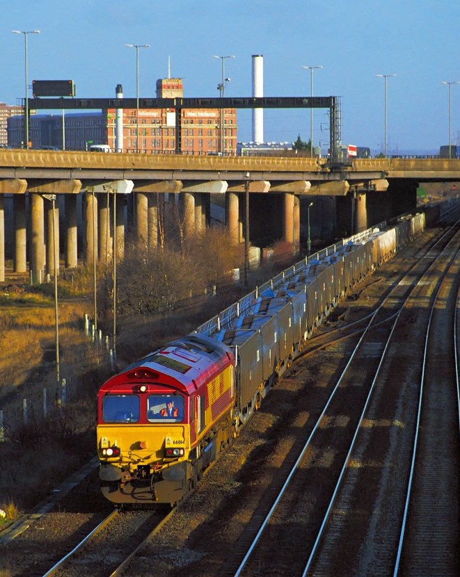
Locomotive 66014 approaches the site of Bromford Bridge Station in 1999 – 34 years after the station & racecourse closed. Looking east from the road junction at Bromford Lane, this scene has not changed much in the last 15 years. Fort Dunlop dominates the skyline, but the M6 motorway has sliced its way through the scene since 1965. |
 |
The River Tame became one of Britain’s most polluted rivers during the 20th century, draining as it does great swathes of the Black Country and Birmingham. This gave it the name locally of “The Black Brook”. However, remarkable efforts were made during the last quarter of the 20th century to improve the quality of the water to the extent that herons have been seen fishing the river between the factories at Bromford Bridge and kingfishers now fly the stretch alongside Castle Vale.
As we come out from under the M6, to our right is the end of the Fort Parkway. This relatively new road was built to serve the industrial units built around Fort Dunlop, and if you take this road it would bring you to the Jaguar car factory at Castle Bromwich. During the Second World War the factories on this site, which were established by Lord Nuffield, produced more than half of the Spitfire aircraft. In the 1960s Pressed Steel Fisher on the same site produced bodies for the Austin Mini, which were taken around the Outer Circle on transporters to Longbridge.
As we head towards Erdington on the Outer Circle we pass over the Birmingham to Fazeley Canal which was completed in 1789. As with all these big projects the whole scheme was mired in controversy with the contractors and the canal company falling out over the materials used and the design of the route. The sorry tale held up the construction of the canal and ended up with the canal company superintendent James Bough being imprisoned for libel and Pinkertons the contractors making a loss of about £2,500 – a large sum in the Eighteenth Century.
We then cross the A38 Tyburn Road which is one of the main commuter routes into the city and forms part of a major trunk road that originally ran from Bodmin in Cornwall through Bristol, Birmingham and on through Derby to Mansfield in Nottinghamshire.
As we head up this last part of Bromford Lane on the right we see The Lad in the Lane pub which was originally Ye Olde Old Green Man, believed to be one of the oldest inns still in continuous use in England. It is a rare example in Birmingham of a cruck-framed building and was originally a private residence. When tested the timbers were found to have been felled in the spring of 1400.
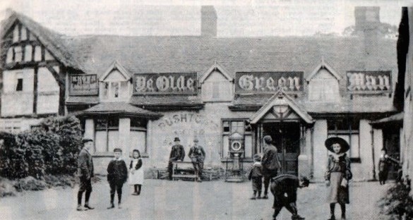
Ye Olde Green Man in Erdington. I’m guessing this photo was taken around 1900.
At top of the hill we reach the end of Bromford Lane where we meet the junction with Kingsbury Road. Along Kingsbury Road to the right is Rookery House, sited in Rookery Park. The house was built for an important local iron merchant Abraham Spooner around 1727. His grandson Richard Spooner was born here in 1783 and became Birmingham’s first Tory Member of Parliament. The politician William Wilberforce, known for his part in the abolition of slavery, married Richard Spooner’s sister Barbara and he lived in the house for a time. In 1852 the house was leased by Abraham Dixon, a county magistrate and merchant, who was brother of the famous civic politician, George Dixon – more about George Dixon later on in our journey.

Rookery House was at one time Erdington’s Town Hall and is now owned by the city but has fallen into disrepair. The Birmingham Conservation Trust is currently engaged in its restoration.
The Outer Circle once again becomes a single carriageway was we pass rows of Victorian Houses, built along Wood End Road as the area around Erdington grew.
On our left we can see the back gardens of the new houses built on the site of the Jaffray Hospital. This was opened in 1885 by The Prince of Wales and was named after John Jaffray, owner of the Birmingham Daily Post and Governor of the General Hospital. The hospital was designed by architect Yeoville Thomason who also designed Birmingham’s impressive Council House that dominates Victoria Square.
We now climb the hill up to Six-Ways Erdington. Built in the late 1880s Wood End Road was the last road to meet the junction at Erdington that gave this location its name.
After Six Ways our bus now takes us along Reservoir Road and over the Sutton Coldfield Branch of the old Midland railway. Erdington Station is located about half a mile up the line to our right on Station Road.
On our left after the railway bridge is the site once known as Erdington Cottage Homes. This was opened in 1900 as the Aston Union Cottage Homes and was one of three established in Birmingham to replace the workhouses that housed the homeless and destitute. The Erdington Cottage Homes were 17 houses for children each run by a foster mother or a married couple. The site included a small hospital, school and swimming baths. The site was closed in 1984 and redeveloped as private housing.
 |
The decorative clock tower that stands in the centre of the Erdington Cottage Homes estate that was first donated by WJ Adams, the Chairman of the Aston Union. This was burnt down by vandals and rebuilt by local craftsmen in 1998.
|
At the brow of the hill on the right there is a grass bank that leads up to the reservoir that gives the road its name.
The name Erdington appears to have come from Henry de Erdington who was granted manorial rights to the area in the Twelfth century. The de Erdington family lived in a fortified manor house just north of the river Tame at Bromford Bridge, the site of which now lies under Tyburn Road.
When we reach the end of Reservoir Road we are at Stockland Green. This was farmland until the end of the Nineteenth century and the name Stockland probably comes from the fact there may have been enclosures for livestock in the area. The oldest houses here would have been built as Birmingham’s urban sprawl engulfed Erdington and the area became part of the City in 1911.
Over to the far right is The Plaza, now a bingo hall. The Plaza cinema opened on Boxing Day 1927. In April 1930 the first talkie was shown here and the cinema closed in 1978. Apparently Handsworth born Violet Pretty got her first job as an usherette at the Plaza before moving to the Palace in Erdington. Violet later became the film actress Anne Haywood.
The stone clad building on the far right of the junction is now a Chinese restaurant, but it was originally the Stockland Inn which was built by M&B in 1924.
Stockland Green was famous for the experimental ‘Tracline’ guided bus system that was laid in 1984 to take the buses on a concrete track of 600 yards from Stockland Green along Streetly Road on our right to the terminus at Short Heath. This was the first of these systems to be tested in the UK. Many lovely mature trees were destroyed to accommodate the ‘Tracline’, which was dismantled just three years later. There are a number of guided busways in the UK now, the best known being in Cambridge which, as is with all such schemes, was thirty-one million pounds over budget and almost two & a half years late opening.
Tracline 85 – This was Britain’s first kerb guided busway. Operated by the West Midlands PTE (Centro) it featured six passenger stations (bus stops), which were equipped with shelters, tip-up seats and electronic information displays advising passengers when the next bus would be due. Access to the stops was by ramp, so even though the vehicles were not ‘low floor’ they were still more easily reached by people with special needs.
The busway “track” consisted of a concrete road surface into which steel guide-walls were set, with the centre strip between the bus’ wheels ‘rough surfaced’ to deter cars from using it and overall landscaping designed to deter pedestrians from wandering where they were not wanted.
We have on our journey been heading in a generally northerly direction, however as we leave Stockland Green along Marsh Hill we start heading toward the south.
Marsh Hill was widened in 1923 when many of the houses we see now were built. Further along at the foot of the hill the road sweeps around the end of Brookvale Park, which is on our left. The park is mainly occupied by a reservoir, which was built along with Witton Lakes higher up the hill behind the houses on our right. The lakes stand on brooks that rise in Kingstanding and Erdington and were created in the 19th century to supply drinking water for Birmingham. They were then in the countryside, and the water relatively clean. Industrialisation and urban sprawl led to the water no longer being fit for drinking, so Birmingham turned to the Elan Valley in Wales for a supply. Brookvale Park Lake covers 18 acres and was used for outdoor swimming early last century; it was a favourite with youngsters as a local venue for outdoor activities. Much of the park between the lake and the M6 motorway was built on in the 1970s.
On the other side of the road before going under the M6 is Witton cemetery, which was opened in 1863 by Birmingham Corporation, the first in the city. It covers 103 acres and the surrounding brick wall is 2 miles long – said to be the longest in the Midlands.
As we continue down what is now Brookvale Road we dive under the M6 once more, leaving residential Erdington behind us to arrive in industrial Witton. The decent down Marsh Lane and Brookvale Road has bought us to the floor of the Tame valley and immediately after the M6 we cross the Tame Valley Canal, the last of the Birmingham canals which was cut through here in 1842. Then on the right we see the River Tame again as it runs along side of the road behind the railings. 300 homes here were flooded when the river burst its banks in 2007.
The area on the other side of the River Tame to the right is known as Holford and gets its name from a ford over the Tame about half a mile away to the north. The industrial buildings that we now see here are built on the site of the ICI & later IMI Kynoch explosives factory. Born near Aberdeen in 1834 George Kynoch became a bank clerk and joined a firm of ammunition manufacturers in Great Hampton Street in Birmingham’s Gun Quarter. Following an explosion in 1861 Kynoch moved the factory to farmland here in Witton and started production at The Lion Works. The business expanded rapidly and ultimately occupied nearly 200 acres of land at this site. Knyoch became MP for Aston and Chairman of Aston Villa, subsequently he was forced out of the company in 1888, unable to meet his commitments. He died in poverty in South Africa three years later. The Company became ICI in 1926 & then IMI in the sixties. IMI left the site in 2007.
The gatehouse and main buildings of IMI (formerly ICI) at Witton Cross in 2003 just prior to demolition.
For the first time on our journey we go under a railway. This line and the nearby Witton Station were opened in 1837 by the Grand Junction Railway as part of a line from Curzon Street to Walsall & on to Manchester.
As we go around the roundabout on our left just down Witton Road is the Aston Manor Tramways Depot that was opened in 1882 for use by steam trams. This was taken over by Birmingham Corporation in 1912 and was closed in 1950; it was subsequently used for cutting up withdrawn trams. It then became a car show room and was then occupied by the Aston Manor Transport Museum from 14 November 1988. The museum closed in October 2011 following a decision by Birmingham City Council to cease funding the museum and the old buses were moved to an industrial unit in Aldridge.
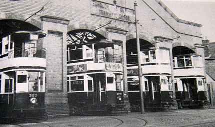
Trams at Witton (Aston Manor) Tram Depot
We turn right now into Aston Lane and we suggest that you take a break from our perambulations at the Tesco store, which is on the right where you find toilets and an excellent cafe on the first floor.
Whilst we enjoy a cuppa, lets look at the history of our wonderful bus route. The Outer Circle no 11 route opened in full on 26 April 1926 and comprised parts of two routes. The original no 11 from Erdington to Acocks Green and the 10 from Kings Heath to the Kings Head Bearwood which both had been introduced in 1923. The gaps were filled in and we have what we now know as the Outer Circle, which with only a few alterations is almost the same as we are travelling today.
~~~
“Our” bus at Tesco in Witton whilst we stop for a cuppa, taken in 2013.
So as we leave the supermarket car park we turn right along Aston Lane. Off to the right at the traffic lights ahead of us is Wellhead Lane. This is reputed to be roughly on the line of the Roman Icknield Street as it made its way to Lichfield. About quarter of a mile along Wellhead Lane is located Perry Barr bus garage, which provides a large proportion of the buses on the 11 route. It is said that at the time it was built the garage had the second largest unsupported roof in the world.
When we come to the end of Aston Lane we will arrive at the Birchfield Road Underpass which takes the A34 road under the Outer Circle.
As we go round the roundabout look to the left and you may see an Asian supermarket on which is on the site of the Birchfield Picture House which opened in 1913 and closed in 1962. The residents of Perry Parr were well blessed for cinemas, as about quarter of a mile further along Birchfield Road is the old Perry Barr Odeon cinema. This is still standing and was opened by Birmingham born Oscar Deutsch in 1930. It was the very first of what was become the UK’s largest cinema chain.
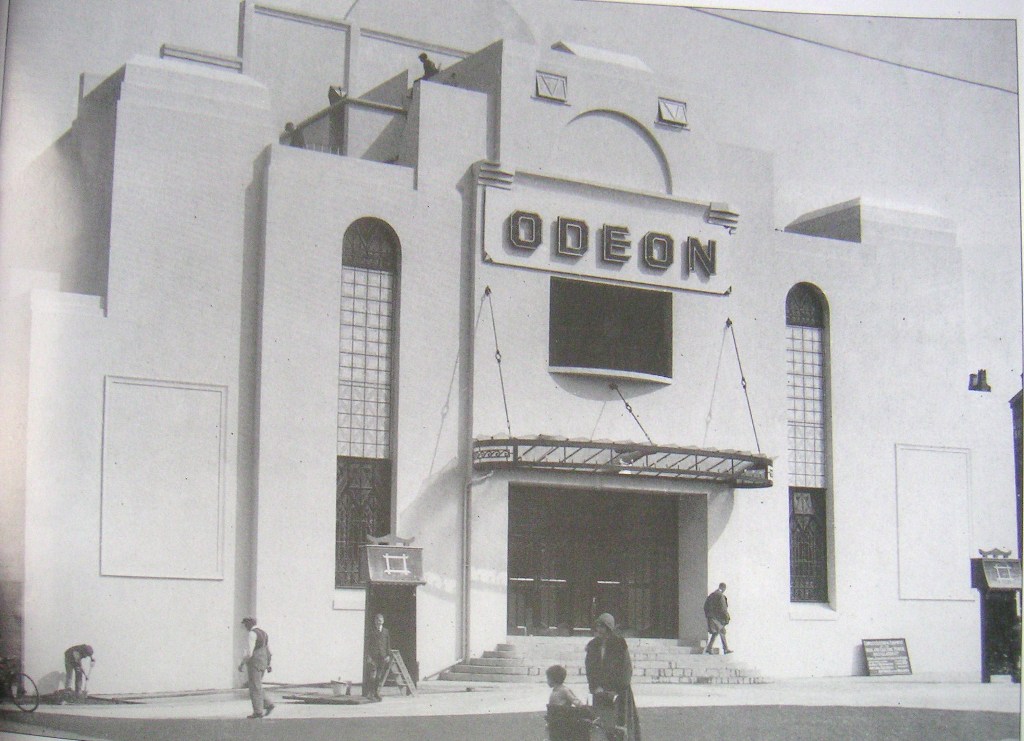
The first “ODEON” Cinema in Birchfield Road.
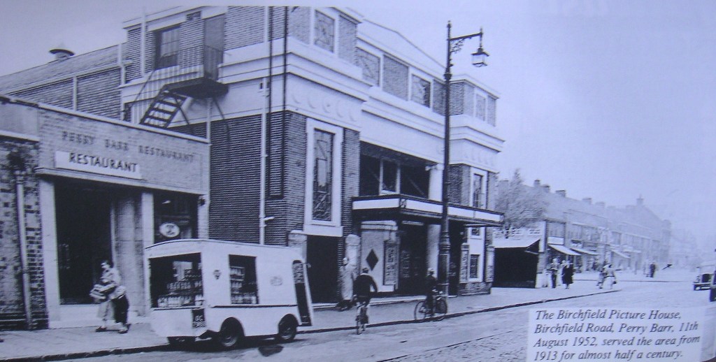
Birchfield Picture House in 1952
After crossing Birchfield Road the Outer Circle takes us into Wellington Road on its way to Handsworth and to our right is the Crown & Cushion pub. The original Old Crown & Cushion which dated from around the 1860s was believed to be the place where Aston Villa football club was formed. This was replaced in the 1930s with a huge Old Crown & Cushion building which was in turn replaced by the current modern building.
As we go along Wellington Road, on our right beyond the houses, factories and the railway is Perry Hall Park. Perry Hall was the home of the Gough-Calthorpe Family. The Gough-Calthorpes are still major landowners today owning significant parts of Edgbaston. Perry Hall came into ownership of the Gough family around the late 1600s. The hall was originally a timber framed manor built around 1576, and was extensively altered in the 1840s in a style to resemble Aston Hall. The parklands around the hall and the building itself came into the hands of Birmingham City Council in 1928 and the hall was demolished, leaving the park as playing fields.

Perry Hall in the 1920s. Today, not far from the entrance to Perry Hall Playing Fields off Perry Avenue, is a rectangular garden surrounded by a brick-lined moat fed by a small stream, which runs into the nearby River Tame. Although this has every appearance of a 20th-century park feature, it is the medieval moat of Perry Hall.
On our right at the junction with Wood Lane is the Calthorpe Arms pub, which recognises the area’s association with the family.
As we travel further along Wellington Road we cross a railway line which was built in 1896 to connect what is now the West Coast Main Line to the north west of New Street to the old Grand Junction line to Walsall. Just after the railway bridge on the right where relatively modern houses & bungalows are built was a yard that was used to store the last of Birmingham’s trolleybuses in 1951 before they were taken away to be cut up at Stratford-upon-Avon.
We are now approaching the junction with Hampstead Road and down here to our left was Handsworth Wood Station which was closed in 1941 and St Mary’s Parish Church where Matthew Boulton, James Watt & William Murdoch were all laid to rest. St Mary’s stands in 4 acres of grounds and is often called “the Cathedral of the Industrial Revolution”.
![Watercolour of St Mary’s Parish Church Handsworth [Birmingham Museums and Art Gallery]](https://outercirclebus.com/wp-content/uploads/2015/01/st-marys-handsworth-3.jpg)
Watercolour of St Mary’s Parish Church Handsworth [Birmingham Museums and Art Gallery]
The row of listed cottages which date from the Sixteenth century which at one time were used as Handsworth Town Hall. They stand behind St Andrews Church in Oxhill Road.
We now travel for about a quarter of a mile along Oxhill Road where in the 1930s the number 11 bus would have had the company of the no 26 tram before we turn left onto Rookery Road.
Birmingham’s most famous forging gang was led by William Booth. He was a farmer with 200 acres of land. At his farm house near to Perry Barr he conducted a massive forging operation imitating Bank of England notes. Unfortunately for Booth one of his servants was arrested in Walsall in 1812 trying to pass a £2 note and he spilled the beans. Following a massive police raid on the farm house Booth was sent for trial along with the rest of his gang, some of whom turned King’s evidence. Booth was sentenced to death. However all did not go well. At the execution Booth, who four years earlier escaped execution when he was acquitted of the murder of his elder brother, seemed to be in luck again when the hangman’s noose broke and he fell the full 10-foot drop. He obligingly climbed the gallows again and had to wait a further fifteen minutes whilst the noose was fixed, but this time the trap door jammed and it had to be forced open. Booth left the huge sum of £6,000 pounds to his widow & daughters and Booth Street in Handsworth is said to be named after him. When we reach the end of Rookery Road Booth Street is about 150 metres to our right up Soho Road.
We are however going to turn left into Soho Road and travel for a short distance towards the city. This was part of the road from London to Holyhead built in the early 19th century by Thomas Telford, which attracted tolls until 1870. It is also worth noting that Soho Road was on the route of the Birmingham cable tramway that ran along here to Colmore Row between 1888 and 1911.
On our left just before we turn off Soho Road is the abandoned Red Lion pub. There was a Red Lion Inn on this site in the 1640s when the stables were used by Cromwell’s troops. The present rather grand building was built for the Holt Brewery. As I write this in 2014 the abandoned pub has just been put up for auction and a better future may be found for it and its fine interior.
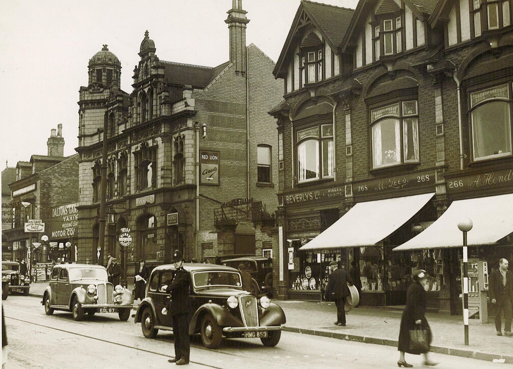
The Red Lion Handsworth in better days, Photographed here in 1949 with locally manufactured Rover & Austin cars bought to a halt by the policeman on “point duty”.
The interior of the Red Lion.
About a third of a mile ahead of us next to Handsworth library is the site of the Elite Picture House which was opened in 1913 and closed in 1966. The building was demolished in the 1980s and recently a new building was erected here, which houses an Indian bank.
As if to reinforce Boulton’s association with the area we now turn right into Boulton Road. The site of Boulton’s Soho Manufactory was about three quarters of a mile down Soho Road towards the city. In the same area and still standing is Soho House, which was Boulton’s home between 1766 and 1809, now preserved by the city as a museum. This is well worth a visit.
Soho House, photographed during an event day in 2011. It was once a regular meeting place for some of the greatest minds of the 18th century. Matthew Boulton (1728-1809) was a founding member of the Lunar Society, a group of great thinkers and inventors who met regularly at his home at Soho House. Boulton’s guests included James Watt, Erasmus Darwin, Josiah Wedgwood and Joseph Priestley.
As we go down the hill you will see that ahead of us in the valley of the Hockley Brook are two railway bridges. The first steel span was built by the Great Western Railway to carry their line between Birmingham and Wolverhampton, then on to Birkenhead. After the electrification of the West Coast Mail Line in the Sixties this route closed to be opened again in 1999 as The Midland Metro Line 1, and later for trains from the re-opened Snow Hill to places such as Stourbridge and Worcester. The tram stop here is called Winson Green Outer Circle.
The second brick arched bridge is carrying the line that goes through Handsworth Wood that we crossed earlier when we were on Wellington Road.
By the time we reach the railway bridges the road we are on will have become Handsworth New Road, and just after the bridges on the corner of Beeton Road on our right is Bishop Latimer’s Memorial Church with its massive tower which was consecrated in 1904.
Down here the road becomes Winson Green Road and we will reach the prison originally built in 1849 on the left. Prisoners from Winson Green were involved in the restoration of the Stratford-upon-Avon Canal in the 1960s, when the National Trust had taken a lease on the Canal and their project manager, by using prisoners and volunteers kept restoration costs down to just £40,000. One of Winson Green’s most famous inmates was Charlie Wilson, imprisoned for his part in the Great Train Robbery; he escaped from the prison in July 1965 and was recaptured in January 1968 in Canada. Alleged serial murderer Fred West committed suicide in his cell here on New Years Day 1995 before he could be brought to trial. Even Ozzy Osborne of Black Sabbath fame served six weeks in Winson Green after he was arrested for breaking & entering and theft in 1966. The last person ever to be hanged at the prison was 20 year old Jamaican, Oswald Augustus Grey. He was executed on 20 November 1962 after being convicted of the shooting to death of newsagent Thomas Bates during the course of a robbery in June 1962. In 1995, the prison was criticised by its own Board of Visitors for being soft on prisoners. This arose after allegations that one inmate had gone on two weeks’ holiday to Minorca, while being released for weekend leave.
After the prison our tour went straight ahead past the end of Aberdeen Street. But if you are travelling on an Outer Circle bus today you will turn left here into Aberdeen Street so that it can stop outside what is now City Hospital. The hospital was opened in 1889 and was originally on the site of the Birmingham Union Workhouse, which was later named Dudley Road Hospital, this is still the name by which it is generally known locally. The hospital’s original ward block was almost quarter of a mile long and based on a design by Florence Nightingale. The original gatehouse known as the “Gateway of Tears” was standing neglected just inside the entrance in Western Road. The Birmingham Conservation Trust have been working to find a sustainable use for the building. Sadly the condition of the building deteriorated so much that it had to be demolished in 2017.
The Archway of Tears could be preserved as a meeting place and community asset. The Birmingham Conservation Trust has been engaged in finding a suitable use for the gatehouse. It was demolished in 2017.
After the Outer Circle bus has been down Aberdeen Street it will turn right into Dudley Road and will cross the ex-LMS main railway line on its way from New Street to Wolverhampton and onward towards the north, along the line to the right was the site of Winson Green station, which closed in 1958. On the same bridge the road crosses the Birmingham Canal Navigation main line which here runs next to the railway on its way from the Black Country to Birmingham.
After the traffic lights on Dudley Road, look to the left to see the trees lining Summerfield Park which was given to the city in 1876 by Lucas Chance the well known Smethwick glass manufacturer. His home, Summerfield House at one time stood in the centre of the park. Lucas & his brother William formed Chance Brothers who were involved in the elimination of the hated window tax in 1851 and in the same year supplied all the 900,000 square feet of glass for the Crystal Palace in London.
We are going to turn left, but about 150 metres ahead of us on Dudley Road is a blue painted building that now houses an Indian takeaway. That was the Dudley Road Picture House which operated from 1912 to 1932. This was replaced by the Grove Cinema which is about half a mile further on. Opened in 1932 and closed in 1981 the Grove was part of the Clifton Group of cinemas, owned by the Clift family who controlled many cinemas in Birmingham. The building is now a bathroom centre and still has the name Grove at the top of the frontage.
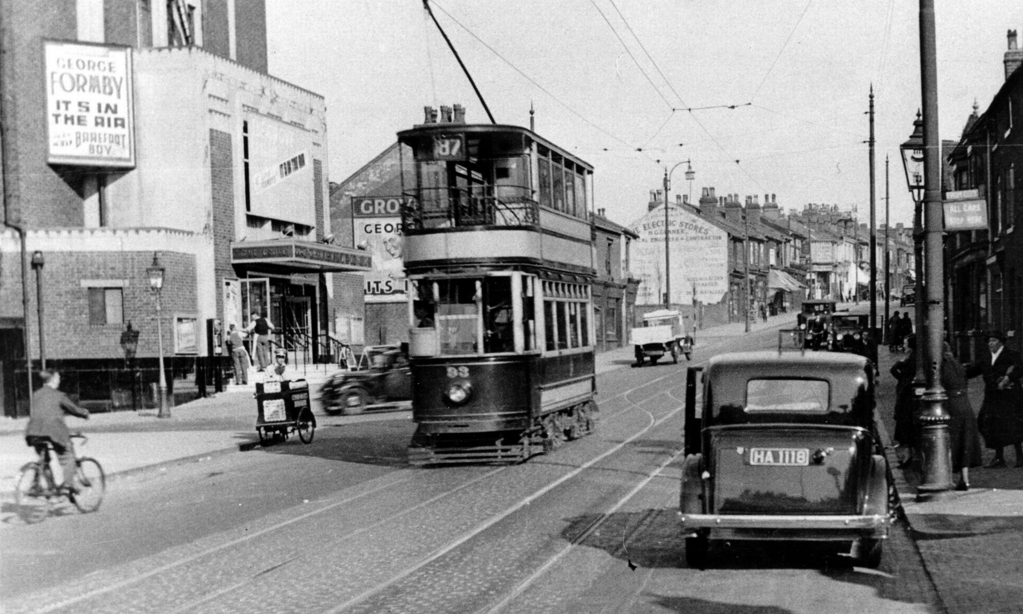
Tram no 93 on route 87 passing the Grove Cinema Handsworth in 1939.
As we turn into City Road the Victorian building to the right on the corner was built in 1903 for Lloyds Bank and was said to be the only bank in Winson Green because other bank owners ignored the area as they believed that the residents were too poor.
Having now left Dudley Road behind us we’re skirting around Somerfield Park and our tour of the Outer Circle has taken us into City Road. This was laid down in the 1890s and at 1.2 miles is reputed to be the longest section of straight road in Birmingham. If you have ever used the phrase “A face as long as Livery Street” then you’d find that Livery Street is only half the length of City Road at 0.6 of a mile. Livery Street is indeed a miserable looking road. It is quite narrow and on the East side is overshadowed by the bulk of Snow Hill Station. But we are on the Outer Circle, so, less information about city centre roads and let’s concentrate on what we have here.
When we reach the junction of Rotton Park Road we are at the highest point on the Outer Circle at 625 feet above sea level. The houses on our left are in front of Summerfield Park and on the opposite side of the park is the trackbed of the old Harborne Railway which ran as a branch line from Harborne to the LNWR near Monument Road. Passenger trains on the line, which was ironically dubbed the Harborne Express, were suspended in 1934 and the track was lifted in 1963. Parallel to the railway trackbed is Gillott Road named after
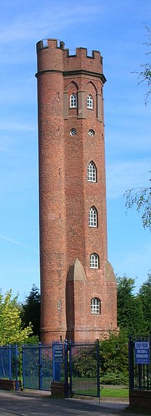
Perrott’s Folly which was built in 1758. There are many theories to explain why the tower was built. One is that landowner John Perrott wanted to be able to survey his land and perhaps entertain guests. Or the tower might have been used to spot animals for hunting. Or that he built the tower so that he could spy on his unfaithful wife.
Joseph Gillott who had made his fortune by mechanising pen-nib manufacture.
Also on our left about a mile away, if only we could see that far, are the two towers of Perrott’s Folly and Edgbaston Waterworks. These, it is said, were visible by JRR Tolkein when he lived as a young man in nearby Ladywood before moving to Oxford in 1911 and were inspiration for his second Lord of The Rings volume. But more about Tolkein later.
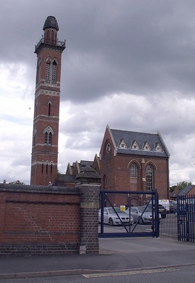
Edgbaston Waterworks Tower. The buildings were designed by John Henry Chamberlain (not a relation of Joseph Chamberlain) around 1870. The engine house, boiler house, and chimney are Grade II listed buildings. Despite the close proximity to Edgbaston Reservoir there is no current or historical connection of the water. This waterworks manages domestic water supply whereas the reservoir was built to feed the canal system.
As we reach the bottom of the hill, on the right, where new housing has been built is the back of the site of the Mitchells & Butlers famous Cape Hill Brewery, which dated from 1879 and eventually covered 90 acres. The factory had its own railway network, which was connected to the Harborne Railway by a branch line crossing City Road along here. The factory was demolished in 2005.
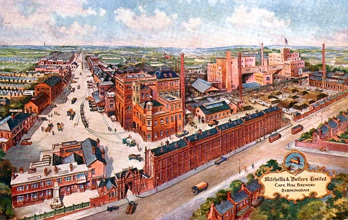
Cape Hill Brewery. Mitchells & Butlers Brewery was formed when Henry Mitchell’s old Crown Brewery (founded in Smethwick in 1866) merged with William Butler’s Brewery (also founded in Smethwick in 1866) in 1898. Henry Mitchell had moved to the Cape Hill site in 1879 and this became the company’s main brewing site.
Further along City Road at the junction of Portland Road on our left is Grade II listed St Germain’s church. This large church designed by E F Reynolds in Romanesque style and completed in 1917 was one of only two churches in the UK consecrated during the First World War.
Next to St Germain’s is George Dixon’s Grammar School. This was opened in 1906 and has Kenneth Tynan the film & theatre critic amongst its famous old boys. Another was Michael Balcon the film producer who in his 1950s film The Blue Lamp named the hero George Dixon after his old school. George Dixon (1820 – 1898) was active in local government in Birmingham and sat in the House of Commons from 1867. He was a major proponent of education for all children.
Back in the day the Outer Circle bus would turn right out of City Road onto Sandon Road then left down Barnsley Road. But now you’ll find that the bus goes straight on into “foreign” territory by venturing into Sandwell. The present 11 bus route now goes straight on along Sandon Road, beyond the city boundary, turning left into to Bearwood Road for the benefit of passengers wishing to avail themselves of the wide array of shops there.
If we’d gone down Barnsley Road to the junction with Hagley Road we would have been above above Chad Brook, which will flow southeast from here to a lake alongside The Edgbaston Golf Course in Priory Road. The Chad, of course, gave its name to the famous Chad Valley range of toys & games. The company, which moved to Harborne in 1897 was one of the UK’s leading toymakers, but the factory was closed when Chad Valley was taken over by Palitoy in 1972. The radio broadcaster Kenneth Horne was Chairman and Managing Director of the company in the 1950s. The brand name was bought by Woolworths 1988. Then Home Retail Group, the parent company of retailers Homebase and Argos, purchased the brand and Chad Valley toys are now available exclusively in the Argos catalogue.
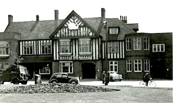
The Outer Circle route now takes us across Hagley Road and we will meet up with the original 11 route as we go into Lordwood Road alongside the Kings Head pub. Holt Brewery opened the present Kings Head in 1905. Although this is located on land owned by the Calthorpe family, who like the Cadburys would not allow the building of licensed premises, this pub replaced a much earlier hostelry, which pre-dated the Calthorpes’ ownership. This circumvented the restriction on pubs on Calthorpe land.
As I write this there is a right hoo-har going on because there is a plan to re-site the “Kings Head Clock” which stood outside of the pub from around 1900 until 1971 when the road was widened. For a time it stood in High Street in the city centre, but now, after extensive refurbishment the council have arranged for it to be sited on the diagonally opposite corner of the road junction – which is in SANDWELL!!!!
The Kings Head Clock in its original location outside of the pub.
Continuing on along the Outer Circle, the Lords Wood that gives this road its name was originally located on land to the right between Hagley Road and Blakeley Avenue which belonged to the lords of the manor of Harborne. Woodland is shown at this location on the OS map dated 1834.
In September 2013 one of our OuterCircleBus passengers made a brief video of the 1953 Birmingham bus that we used for our tours as it went along Lordswood Road – take a look at it here: https://www.youtube.com/watch?v=KfUcaHbJTHA
On the left we will see the House at Home pub. Not particularly remarkable, but I will refer to it later in our journey.
The next road on the left is Carless Avenue leading to the Moor Pool Estate which was established in 1907 by John Nettlefold, first chairman of Birmingham Housing Committee and member of the Guest Keen Nettlefold company (GKN). It was part of the Garden City concept shared by the Cadbury family in Bournville, to provide low density housing centred on a community hall with many green spaces, at a time when the majority of inner city housing was crowded back-to-backs. Five hundred houses were built which can still be seen today. The Estate boasts two tennis clubs, a bowling green, allotments and the Moor Pool itself, with an active fishing club. In the Moor Pool Hall there is an acclaimed dramatic society, a unique skittle alley dating back to 1913 and snooker tables. Developers have plans to knock down the community facilities and a trust has been set up to raise over £300,000. In December 2014 it was announced that the Moor Pool Trust has raised sufficient money and along with a Heritage Lottery Fund grant they have secured the facilities for future generations.
As we head down Lordswood Road towards Harborne we might like to reflect upon the fact that rural Harborne was a centre for the growing of gooseberries. In fact the Gooseberry Growers’ Society annual dinner was held at the Green Man pub at the far end of Harborne High Street from 1815 up to the 1920s. Furthermore the district was also known for its healthy location: “Harborne being situated upon very high ground, and the soil light, renders the air very salubrious; instances of longevity being very numerous, particularly one couple, James Sands and his wife, one of whom lived to the age of 140, and the other to 120.“ said Charles Pye in his 1818 “A Description of Modern Birmingham”
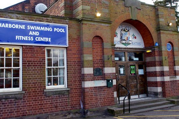
On the right as we enter Harborne look out for the modern building which is the Swimming Baths, originally opened in 1923. The poet WH Auden lived in his father’s house next to where the baths are located between 1919 and 1939 when he moved to the USA. His father was the Chief Medical Officer for Health in Birmingham. Auden was born in York in 1907 and died in 1973.
The original Harborne Swimming pool opened in December 1923
There is a cinema in Harborne High Street which was the Royalty Cinema, boasting a ‘high quality Art Deco interior’. In the summer of 2011, the Royalty Cinema was designated Grade II Listed by English Heritage.
Royalty Cinema Harborne – interior Art Deco feature above fire doors
The Outer Circle route now takes another one of the famous dog-leg turns out of Lordswood Road through the end of Harborne High Street into Harborne Park Road. When we last went past in 2014 we looked up at the pub on the corner and saw that the roof is missing. This was the Kings Arms, which was changed into a Tolkein theme pub called the Huntsman in 2013 by a hairdresser then the roof caught fire in July – he’d probably left his curling tongs plugged in! By September 2015 the building had been demolished to first floor level. In 2017 it was completely demolished and apartments are being built on the site.
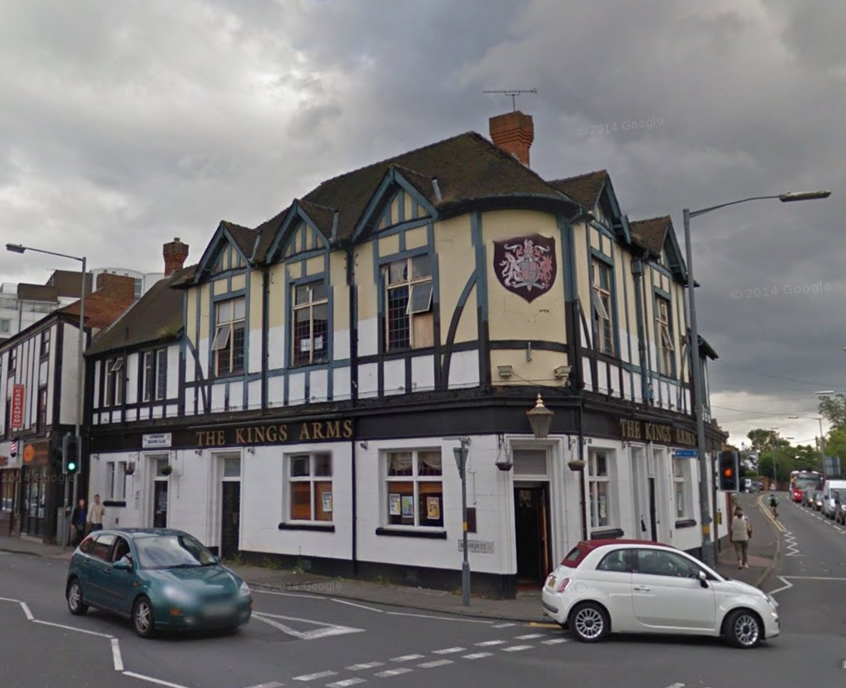
The Kings Arms in Harborne in 2012 before the fire that devastated the roof.
Further down Harborne Park Road, on our right is Old Church Road and along here we would find Harborne Hall, once home to a succession of notable Birmingham families including Walter Chamberlain brother to politician Joseph Chamberlain and members of the WT Avery family, remembered for their weighing machines. The hall was latterly a convent and is now used as a conference centre and hotel. Further along the same road is St Peter’s Church, parts of which date from the 14th century and the church school dating from before the mid 18th century which is grade two listed.
As we descend the hill Harborne Park Road becomes southbound only, the northbound traffic a few metres away to our right is in Harborne Lane.
Look to the left as we start to go around the roundabout and you will see the new Queen Elizabeth Hospital building above the trees. This now houses most of the activities from the old QE & Selly Oak Hospitals including the Royal Centre for Defence Medicine which was previously located at Selly Oak. The facility, which opened in 2010 has the largest single-floor critical care unit in the world, with 100 beds. The new hospital cost a total of £545,000,000, has 1,213 patient beds and 30 operating theatres. There are 3,800 car parking spaces so I suppose that there’ll be plenty of income from those then! The original Queen Elizabeth Hospital was opened in 1938 and stands on land originally donated by the Cadbury family.
We then continue up the hill to where a new roundabout is located. Look to our left to see the new Selly Oak Relief Road, which opened in 2011 and is intended to divert traffic on the busy A38 away from the congested Bristol Road. The patch of disused land on the left next to the new road is planned to be the site of a new Supermarket. However it currently seems that Sainsbury’s may be reneging on their agreement to develop the site.
As you look left down the new Selly Oak By-Pass you can see the University Clock Tower. Birmingham University claims to be the only university campus in Britain with its own railway station.
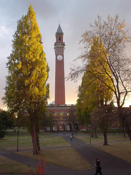 |
The University of Birmingham Clocktower. Built in 1900, the clock tower was the tallest building in Birmingham until 1969 and is nicknamed “Old Joe” after Joseph Chamberlain, the University’s first Chancellor. It is a prominent landmark visible from many parts of the city, and is said to be the tallest free-standing clock tower in the world at 100 metres. |
As we go down from the roundabout we cross the point where the Dudley No 2 Canal once went as a new route to Birmingham avoiding the busy Birmingham Canal (which we crossed when we were on Winson Green Road). Opened in 1798 it was built on the cheap and the tunnel at Lapal was constantly collapsing. The canal was closed in 1926 it now ends in Halesowen. The line of the canal was visible below the new bridge that was built here in the 1920s for the Outer Circle and it ran behind where the retail estate is to our left, to a wharf for the Birmingham Battery Company and then joined the Worcester Canal. The bridge was replaced during the on-going road improvements, and the canal has virtually vanished.
On our right now is the old Selly Oak bus garage, which opened in 1927 as a tramcar depot. Buses shared the garage until 1952 after the Bristol Road trams ceased operation and it finally closed in 1986. Selly Oak provided buses for the Bristol Road routes, the Outer Circle and housed the Leyland single deck buses that were used for the no 27 route through Bournville.
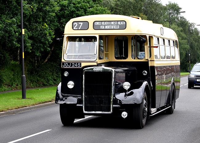
One of Birmingham City Transport’s Leyland PS1 single deck buses no 2245 now in preservation at Wythall Transport Museum. Shown here with the route number 27 which it worked for most of its life. The 27 ran from Kings Heath through Bournville to Northfield. It was the tunnel under the railway & canal in Bournville that meant only single deck buses could work the route.
The retail park on the left is on the site of the IMI Eliott works, a major employer in the area and next to it was the Birmingham Battery Company. There was much controversy when the site closed because of contamination of the land, but there are now plans for developing the area around the Worcester Canal which runs through the site with retail, leisure and business facilities.
![The Birmingham Battery and Metal Company offices - Bristol Road, Selly Oak before demolition. [Bob-Embleton]](https://outercirclebus.com/wp-content/uploads/2015/01/birmingham-battery-and-metal-company-offices-bristol-road-selly-oak-bob-embleton.jpg)
The Birmingham Battery and Metal Company offices – Bristol Road, Selly Oak before demolition. [Bob Embleton]
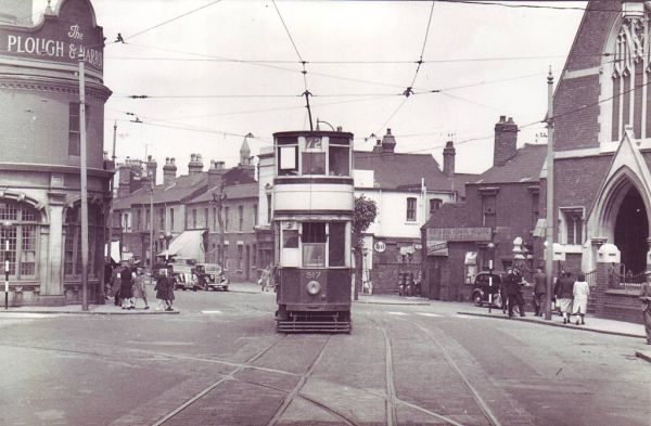
Tram on the Bristol Road in Selly Oak in 1952. the Plough & Harrow is on the left.
A right turn takes us onto Bristol Road, the A38. Those with a good memory will remember that we crossed the A38 earlier at Tyburn Road.
When we turn from the Bristol Road into Oak Tree Lane we pass the alleged site of the original “Selly Oak” which was felled in 1909 amid concerns about its safety and damage it was causing to the nearby buildings, which are now shops. There have been three new “Selly Oaks” planted in the area since 1985. The original was on the pavement outside a house what is now the offices of Bevitts Solicitors.

The Selly Oak in Oak Tree Lane in 1908, a year before it was cut down.
As we go along Oak Tree Lane, to the left is the familiar site of Selly Oak Hospital, now partially closed, which originally occupied the buildings of the Kings Norton Union Workhouse. This is now the third of the workhouse sites in Birmingham that we have passed, the others being in Erdington & Handsworth.
At the top of the hill here Oak Tree Lane veers off to the right and the Outer Circle follows Linden Road as we enter Bournville.
The Cadbury brothers George and Richard bought their chocolate making business here to Bournville in 1879 from Bridge Street off Broad Street in Birmingham where the Hyatt Hotel now stands. The Cadbury name and Bournville are synonymous with the “Garden Village” that the brothers created here to improve the lives of their employees.
On the right after the junction with Woodbrooke Road is the Bournville Carillon built in 1906 with 22 bells, it was increased to its present 48 bells in 1934. According to the Carillon website it is played at 12 noon and again at 3pm on Saturdays.
On the left is Bournville Village Green and amongst the trees is Bournville Rest House, which was built in 1913 paid for by the factory employees. The octagonal design is by W Alexander Harvey and is based on Dunster’s medieval Yarn Market in Somerset. It is currently the Carillon Visitors’ Centre. An inscription inside reads: ”This Rest House was erected to commemorate the Silver Wedding of Mr & Mr George Cadbury by the employees of Cadbury Brothers at Bournville and in all parts of the world. A lasting memorial of esteem and affection as an expression of gratitude for the unceasing interest in their welfare and in admiration of manifold services to the world at large”. A tribute indeed.
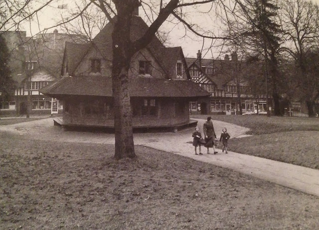
Bournville Village Green and the Rest House in 1960. Bedford Tyler’s ‘country town style’ row of shops is in the background.
On the far side of the green you can see the moated manor house, Selly Manor (also known as Bournbrook Hall) which originally stood in Bournbrook Road at the north of Selly Oak, It is known to have stood there in 1327, and the house was extended in the Tudor period. However, by the late 19th century its earlier status was long gone, it was being rented out as three separate lodgings and falling into disrepair. With the rapid development in the district of terraced rows the house was due to be demolished. In 1907, busy establishing his vision of a Bournville village, George Cadbury, saved it from demolition. He employed the architect William Alexander Harvey to oversee its relocation to Bournville Green in 1914. Within its grounds also stands the magnificent cruck-framed medieval hall, Minworth Greaves. Dating from the 14th century it originally stood in Minworth and like Selly Manor was dismantled by the Cadburys and re-erected here in 1932. The buildings are now a museum and wedding venue owned by Bournville Village Trust and they are open to the public.
![Selly Manor with the bus that we used for the original “Outer Circle Historic Bus Tour' on 11-11-11. [With thanks to Jay Hooper]](https://outercirclebus.com/wp-content/uploads/2015/01/selly-manor-on-11-11-11.jpg)
Selly Manor with the bus that we used for the original “Outer Circle Historic Bus Tour’ on 11-11-11. [With thanks to Jay Hooper]
As we climb out of the valley and approach the junction with Bournville Lane behind the brick wall on our left once stood another Bournbrook Hall but this one was demolished by the Cadbury Brothers.
Surviving on the opposite side of the road is the Old Farm Hotel, which was a cider house. When the Cadburys bought the land their Quaker beliefs would not allow the sale of alcohol so the inn was closed, but it is said that they took on the landlady as a tea lady in the factory!
When was the last time we saw a pub? Since we saw the House at Home in Lordswood Road (remember that?) the Duke of York in Harborne was replaced by flats during the last few years, the hairdresser let the Kings Arms catch fire and the Golden Cross by the QE was demolished in 2011. There were three on Outer Circle corners in Selly Oak, but they all went when the Bristol Road was widened in the 1970s, and of course there won’t be any in Bournville. I think that we’ll find the next one is the Grant Arms in Cotteridge.
Franklin Road marks the end of Bournville and the Outer Circle becomes Watford Road as we head into Cotteridge.
Many of the shop buildings around the centre of Cotteridge here are now over a hundred years old and as we turn left out of Watford Road on our right is the site of Cotteridge Bus garage now occupied by retirement flats. Originally this was a tram depot and in October 1942 tram no 821 had been left waiting to turn into the depot. The brakes had not been applied correctly and eventually the tram set of on its own down the hill. When it reached the Breedon Cross pub at the bottom of the hill by the canal bridge it failed to take the bend and overturned. Thankfully no one was injured. When we turn off the Pershore Road you will see the shop on our left at the junction, which was a newsagent at the time where the tram came to rest.
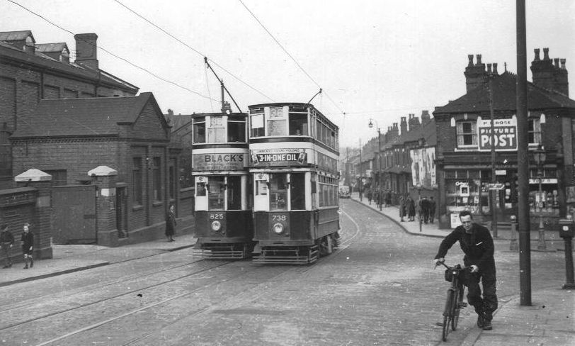
Tram 738 & 825 on Pershore Road at junction with Fordhouse Lane. The shop on the right is where the runaway tram came to rest in 1942.
As we start going down Pershore Road look on your right for Kwik Fit Tyres next to Lloyds bank. In the 60s this was the location of the Treasure Trove. Originally located nearer to the tram depot the Treasure Trove was a huge second hand goods shop, the like of which you rarely see now.
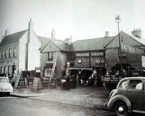
The Treasure Trove on Pershore Road in Cotteridge close to the tram depot.
As we go along Pershore Road we go across two railway bridges. These cross over two sides of the triangle formed where the main Midland Railway line from New Street through Bromsgrove to Bristol meets the Camp Hill line which heads north to Derby from here avoiding New Street.
As we head towards the foot of the hill you see on your left the premises of Graham Plumbing. This building was a theatre, which originally opened in 1923 as a silent cinema and music hall known as the Kings Norton Palace of Varieties. Ten years later it was refurbished and reopened as the Savoy Cinema; it closed in 1958 and became the Savoy Works, the home of an engineering company Wavern Engineering.
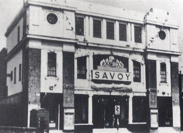
The Savoy Cinema in Cotteridge
Across the road at the junction with Lifford Lane at one time stood the landmark Breedon Cross pub that was left derelict and was eventually destroyed by fire in 2001. The building on the site now is a block of flats built in 2004. The bridge that we then cross carries the road over the Worcester Canal. If we were to follow the canal for about half a mile to the south (our right) we would reach the junction with the Stratford-upon-Avon Canal. In the heyday of the canal network this was separated from the Worcester canal by a unique guillotine lock, which prevented precious water getting from one canal to the other. The lock is still there and can be seen from the canal bridge.
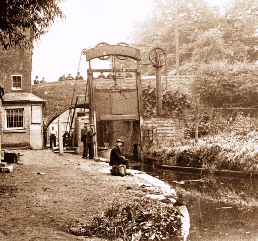
One of the Guillotine Lock Gates at Lifford Lane Bridge on the Stratford-upon-Avon Canal. The building to the left is the toll collector’s office. The lock gates were located about 350 yards from the end of the canal where it joins the Worcester Canal. This first section of the canal was completed to Lapworth by 1802. Since the nationalisation of the canals in 1948, water loss from one canal to another is less of an issue, so the gates are no longer in use and are both left open. The last recorded use of the gates was 1959. This photo shows how fascinated the English are by canals – there are spectators in abundance on the bridge and the canal side even in these early days. Or are they supposed to be working?
We turn now off the Pershore Road on to Fordhouse Lane. The firework shop ahead of us is where the runaway tram came to rest on its side in 1942.
Along here on the left is the site of the Willmot Breeden factory. They expanded here in 1972 from their huge site in Tyseley. After the second world war almost every car driver would have had a Willmot Breeden product in their pocket as they made car keys and locks as well as other components such as door handles and bumpers.
Just after the factory site we cross the River Rea as it wanders northwards past Cannon Hill Park on its way to Digbeth then on to meet up with the Tame near Spaghetti Junction.
When we approach the top of the hill we will see on our right the Camp Hill railway line. Built by the Midland Railway as a route north avoiding New Street, at one time this was a suburban commuter line and had stations in Kings Heath, Moseley and Brighton Road in Balsall Heath. The passenger services were axed in 1941 and they never returned. There are plans to open some of the stations and run three trains an hour between Moor Street and Kings Norton. We’ll see!
Pineapple Bridge after being widened in October 1930, the church of St Mary Magdalen can be seen on the left, the bus going over the bridge was an AEC 504.
This area is known as Hazelwell and the land belonged to the Hazelwell family in the 14th century. Away on our left as we turn at the top of the hill is the Hazelwell pub which stands on the site of the last Hazelwell Hall, the original which has connections to the Civil War, was located in the recreation grounds beyond the pub near to Stirchley.
At the top of the hill we now cross the railway on Pineapple Bridge and start our straight run to Kings Heath. Vicarage Road is 0.8 of a mile long – even this is longer than Livery Street! Until the development of the Alcester Road in 1767 this area was mainly agriculturally undeveloped heathland standing on part of the royal manor of Kings Norton. Hence the name Kings Heath.
Vicarage Road was originally known as Bleak Lane. Along here on the left was Priory Farm, which dated from the 17th century and was the home of gun maker William Deakins of Sarehole Mill. This was bought by brass founder James Cartland, an ancestor of the prolific novelist Barbara Cartland, along with about 13 acres of land. He rebuilt the farm house in a Gothic style and called it Bleak House. Upon the death of Cartland’s successor Major Howard Cartland in 1940 the land was sold for the building of King Edward VI Camp Hill Schools, which opened here in 1956.
On the right, after we have passed the crossroads, you will see Stanley Road, and during WW2, at number 9 lived Anthony Pratt. “Who was Anthony Pratt?” you may ask. Well, lovers of board games will probably be surprised to learn that around 1943, Pratt, a solicitor’s clerk, invented Cluedo. It was behind the wartime blackouts at No.9 that he devised the much-loved game, which he initially titled simply ‘Murder’. His wife Elva created the board and artwork. Cluedo was Pratt’s sole board game success. ‘Battleships’ sank without trace, ‘Treasure Hunt’ lost its way. But Cluedo, patented in 1944 and mass-produced by Waddingtons from 1949, has made millions of pounds for the company and is still hugely popular. The company persuaded Pratt to sell them the rights to the game and they offered him £5,000 (£100,000 in today’s money) and he took it. A blue plaque commemorating Pratt’s invention is now attached next to the front door of number 9 Stanley Road. Author Jonathan Foster – a Cluedo devotee – has splashed out £400 for the blue plaque, and has written a book The Cluedo Story: How Anthony Pratt Invented The Game Of Murder Mystery.
Also on our right is the Grade II Listed Ye Olde Red Lion public house. Built in 1903 in a traditional Cotswold style, this was probably the first Birmingham ‘reformed’ pub. Birmingham was an early participant in the movement to replace the small street-corner drinking dens with public houses where a man and wife could drink and eat in well-designed respectable surroundings. They were modelled on an ideal of the village pub at the heart of its community.
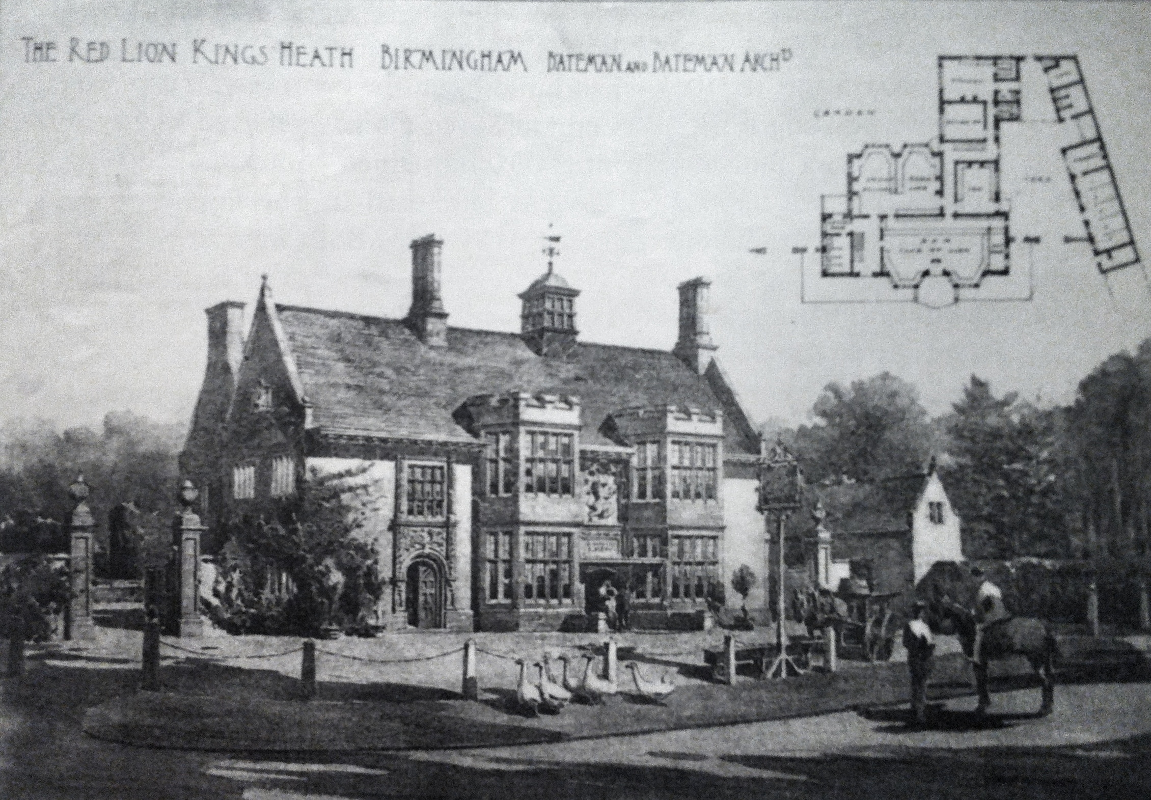
The bucolic scene of a wandering gaggle of geese and a man on horseback envisaged by CE Bateman the architect in his architectural sketch of Ye Olde Red Lion. In the early 1890s, the Priory Trust owners of the land in this area asked Bateman to lay out a middle class suburb on its land, which at the time would have been at the very edge of Birmingham. The houses were designed in a variety of Arts and Crafts styles.
On the left after the school is Kings Heath Park in which stands Kings Heath House. Built in 1908 this replaced the original building of that name which was destroyed by fire during the Birmingham ‘Church and King’ Riots of 1791. The building has had various uses including a school and training centre and the Birmingham Horticultural Training School has been housed here since 1952. Part of the park has been used in the past by the BBC for gardening programmes, but of course the BBC doesn’t think Birmingham exists any more.
At the end of Vicarage Road on the left we can see the new Kings Heath Square, which has been created out of land at the end of the road and the churchyard of All Saints Church. There’s a farmers market here every Saturday. Who remembers the subterranean toilets on the traffic roundabout just here?
We now take a right turn (only buses are allowed to turn right here) onto Alcester Road South with the High Street behind us. Then we take a left turn into Addison Road, which is lined with rows of Victorian terraced houses. On the 28th of July 2005 a tornado hit the area and caused damage to properties in Kings Heath, Moseley and worst of all in Balsall Heath.
Addison Road becomes Brook Lane at the junction with Barn Lane and continues along to Billesley. On our right the pub now called The New Billesley was originally built as the Billesley Arms in 1927 and replaced a much smaller late 18th century road house.
At this junction the Outer Circle bus would have originally turned left to go down Coldbath Road. Coldbath Road must be the narrowest road on the 11 bus route and this was not a problem up until the 1960s when car ownership expanded and the residents were forced to park their cars on the road as it is lined with Victorian terraced houses with no off-street parking. In 1986 the bus route was diverted straight on along Brook Lane, which was originally planned as a dual carriageway. We are going to take the new route as we head towards Swanshurst Park, and then turn left into Yardley Wood Road along the side of the park so that we can join the original route.
As we go along Yardley Wood Road in the park on our right we may catch sight of what is called Moseley New Pool. This was created by around 1759 by constructing a dam across a small stream that rises near to Brook Lane to create a Fish Pond. It was called the “New” Pool to distinguish it from three other pools that were dug on adjacent Coldbath Brook that were intended to regulate the flow to Sarehole Mill.
This autumnal scene shows Moseley New Pool in Swanshurst Park, but it has been known by other names in the past, including Swanshurst Lady Pool and Grove Pool. Coldbath Brook was dammed to create the New Pool as a fish pond in or before 1758. In its hey day Swanshurst Park had a boathouse with boats to hire, a pitch and putt golf course, changing rooms for sports, toilets and a cafe.
One of those pools is in the golf course, which is on our left as we go round the roundabout into Swanshurst Lane. This feeds the Coldbath Brook which runs down the hill behind the houses on our left in Swanshurst Lane. In the area where the brook runs are the sandpits called Moseley Bog which several years ago was rescued from development by the intervention of botanist & broadcaster David Bellamy because of its rich flora. Moseley Bog was declared a Site of Special Scientific Interest in 1980.
On our right towards the bottom of Swanshurst Lane is Bibsworth Avenue – the houses here are on the site of Sarehole Farm where Matthew Boulton’s father lived for the last few years of his life until his death in 1759. In 1755 Boulton senior took over the lease of Sarehole Mill where they rolled sheet metal for six years although the family business was still based in Snow Hill in Birmingham town centre. Boulton junior moved all production to his new Soho Manufactory on Hockley Brook that he built in the 1760s.
On the left at the bottom of Swanshurst Lane is Wake Green Road, and about 200 metres from the junction is no 264 where JRR Tolkein lived as a child. Tolkien was inspired by the area, the “Bog” was his “Middle Earth” and Sarehole Mill across the road was featured in his Lord of the Rings volumes.
Number 264 Wake Green Road. In the summer of 1896 JR Tolkien’s mother Mabel and her two sons settled at 5 Gracewell, now 264 Wake Green Road, a cottage in the hamlet of Sarehole in the north Worcestershire countryside close to Moseley. Most of the area was still farmland. Tolkien said Sarehole was the model for the Shire, home of Bilbo in The Hobbit. He also said that hobbits were partly modelled on the people he knew there. He made the hobbits small in stature because the people were small in imagination; but he said they could be great in courage.
The view of Sarehole Mill, but not as Tolkien would remember it – there were far fewer trees then. When Tolkien refers to a ‘great mill’ in The Hobbit he was probably remembering Sarehole Mill. From 5 Gracewell the boys and their mother could look across the water-meadow to the mill. Tolkien mentioned the miller and his son, George Andrew senior and junior, in the Foreword to The Lord of the Rings. It is perhaps understandable that the miller shouted at him and his younger brother when they played in the mill-yard, as they were very small and there was dangerous machinery there!
So, once we have gone around the final roundabout at the bottom of Swanshurst Lane we have arrived back at our starting point outside Sarehole Mill.
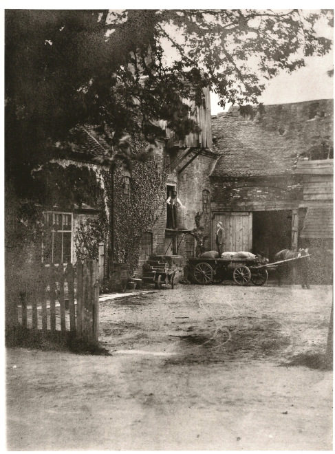
Sarehole Mill in 1870 seen across the yard from Wake Green Road, close to where the bus stop is now.
At the end of our tour we might like to reflect on the fact that modern double deck buses each carry as many as 70 people and the 47 buses that run the Outer Circle route now carry in total about 50 thousand passengers each day.
~~~
BRUM’S SOCIAL COHESION
An important social consequence of the predominance of small businesses in Birmingham was that there were no great divisions of wealth or social status between master and employee; in fact there was not even a clear distinction and it was not uncommon to be an employer one day and an employee the next, depending on how things went. This being the case, bosses and workers were quite happy to live cheek by jowl in the same street. This accounts for the mix of large and small houses, and it made Birmingham starkly different from the northern industrial towns, where the stereotypical mill owner, fabulously rich and living in a hilltop mansion, was widely separated in every sense from his badly paid employees in their huddled courts in the valley below.
As Richard Cobden (a contemporary of Birmingham MP John Bright) wrote, ‘The social and political state of [Birmingham] is far more healthy than that of Manchester. There is a freer intercourse between all classes than in the Lancashire town, where a great and impassable gulf separates the workman from the employer … the industry of the Birmingham hardware districts is carried on by small manufacturers, employing a few men and boys each, sometimes only an apprentice or two, whilst the great capitalists in Manchester form an aristocracy.’
~~~
So this is the end of our Outer Circle tour. I hope that you’ve enjoyed it. Let us know if you’ve found anything that you’d care to add to the commentary, or just to tell us how you undertook your tour.

I live in Canada now but lived in Church rd Yardley. As a child my mother would send us kids on the no 11 for the full circle during the summer holidays. Gave her some piece for a couple of hours. Nostalgia I realize progress is unavoidable but isnt it a pity so many places were knocked down. Great stuff thanks.
Hi Roy. Thanks for your memory of the Outer Circle. So many pubs have been knocked down as has the whole of Church Road nearest to the Swan. If you’ve not done so, take a look on Google maps. Progress!
David
Wonderful memories recalled by this …and its seems to be a recent tour as its up to date on a lot of places mentioned….greatly enjoyed.
…
Hi Pauline – sorry that I’ve not replied sooner.
Yes we do try to keep the tour current and it is due a refresh in 2017 to bring any changes up to date.
If you know of anyone that belongs to local history societies let them know about our one hour illustrated talk. A two and a half hour journey in 60 minutes!
Thanks for visiting.
D
Hi I have been on your tour and found it very informative and brought back a lot of memories. I must have travelled on the No 11 thousands of times but I have never been all the way round until now so thanks.
I am on the Birmingham forum so if you don’t mind I will post it for all the members to have a tour i’m sure there will be many takers.
townie
Hi – thank you for your kind comment.
Yes, please post details of the “self guided tour” on the Birmingham forum with a link to the page where the TOUR! is.
If you, or anyone you know are members of history societies, or similar organisations in Birmingham, please be aware that we also deliver a 60 minute talk covering the Outer Circle and other talks about the Coffin Works, Back to Backs & Hippodrome. We can be contacted through the OuterCircleBus.com website.
Best Wishes – Pam & David
Brilliant tour so many lovely photos and so much local history, thank you.
Hi Anne
Thank you for your lovely comment. The Outer Circle is another one of Birmingham’s hidden gems!!
Regards
David
A arrived in B.ham aged 9 left 34 .Loved the tour and the cinemas I must have Been to,Cycled the inter ring road to work but ravelled the 11 route by bus over the years.Such a pleasure making the journey tonight.I will perhaps dream tonight ,a happy dream.THANKs.
Great tour , really enjoyed reliving it again , spent many hours going to school along the route .
Will you be doing any tours this year ?
We do not plan to conduct any more of the tours. We ran them for four years and have now moved on to other things.
A great piece of nostalgia, with many memories from chidhood, it would be nice to see photos (old and new ) of Winson Green Prison. What a shame there will not be any more tours around the no 11 – every Brummie knows this route and as kids we all ran upstairs to sit in the front seat , to ‘drive ‘the bus !
Thanks for your comment. Why not take a normal Outer Circle bus and take a copy of The Tour! from this website, so that you can find out what you are passing? Just remember to take the 11a as the tour on the website is in an anticlockwise direction.
A tour of the no 11 is definitely on my ‘to do list ‘…. i have already done the shorter inner circle 8 route !
A memorable journey for me as a driver at Quinton Garage which at the time did not run the No.11 I was sent to Harborne Garage for a days work who put me on the No 11 with a conductor. Will always remain in my memory as an unforgettable experience as had never driven the route before. After 20 years ‘on the buses’ and now living in Australia many thanks for ‘The Tour’
I went on the full route many times as a child with my Gran in the school holidays. I recall meat paste sandwiches and pop and a stop off at a park with the most enormous slide think it was called Queens Park? She couldn’t get me off. My husband and I now both retired were considering a trip around the circle, didn’t know there was a special service, wondered why we used to see the No 11 on Tesco car park. I understand this tour is no longer, what a pity, lovely reading, Birmingham has so much history
Congratulations on a most interesting
and informative article.
It certainly brought back very happy
memories to me as I worked on the buses from Shelly Oak garage in the
1950s. The routes I was on were the
27/61/62/63.
I still have my badge.
Mick geary
Thanks for your comment Mick. I probably travelled on one of your buses back in the 60s as I travelled on all of your routes, and of course the no 11. D
A fascinating description of the outer circle. Thanks for publishing it.
Thank you Andrew – we’re pleased that you enjoyed our tour. D&P
As an exiled Brummie i hope to catch the 11 at Perry Barr during the next week or 2.
Regards from Spain.
Just found this . I was a student at Aston in 1969-74 . I miss Brum . Lots of memories in your article. We lived in Gillott road, Kingsbury Road to name two . Would love to do the tour . Is it still possible and how long would it take. Tea break toilet stops etc.
are there any organised tours?
Thank you for your comment. We haven’t done the Outer Circle tours for several years. However we have a “Virtual” Tour in the form of an illustrated talk that we conduct for histories societies, U3A groups etc.
I’m just preparing for a trip back from Cornwall this week to ‘do’ the no. 11A & found your account full of fascinating detail and history. After living my first 45 years in Birmingham I realise now that the full route will take me not just to formerly familiar locations but also to a few places I have never been!
Hi Paul. I hope you enjoy your trip and your journey around the Outer Circle. Please note that the route has been “split” into two and you need to change buses in Witton and Acocks Green. You can follow the route, whenever you start, using the “Tour” button on this site. Best wishes D.
Church Road junior school was on the Outer Circle route and Dennis Amiss, the England and Warwickshire cricketer, was a pupil. graduating in 1954. I was the same year and recall the truly dominant force he was in school sports.
I subsequently attended George Dixon Grammar School for boys and rode the Outer Circle to and from Kings Heath. One day, a group of us on the sprint relay team practiced after school and all took the Outer Circle. We arrived at the bus stop just as the bus was pulling away and signaled for it to stop. It didn’t. So the four of us, all being very fast sprinters, ran after the bus and boarded at the back platform one after the other as it gathered speed.
I recall one of the GD students, climbed to the top deck and called out “Tickets Please” and the passengers got out their tickets and nothing was inspected.