
The Outer Circle now approaches what will be forever known as The Swan, although there is no longer a pub here with that name. The first known “Swan” inn was recorded in 1605 sited on the left before the junction.
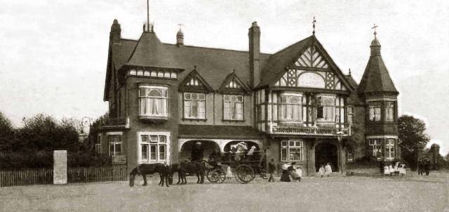
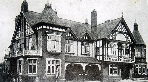
Then a much larger new pub in a Tudor style was built in 1898 behind the old one, which was then demolished. This is probably “The Swan” that most people a certain age will remember.
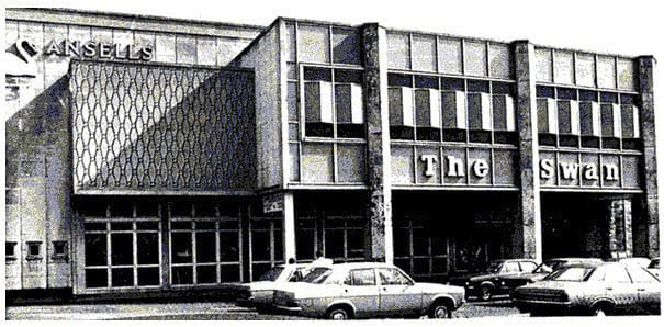
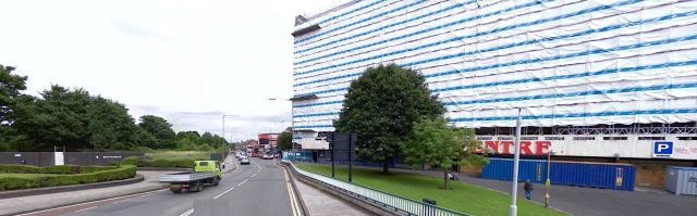
When the Coventry Road underpass was constructed in 1967 this was demolished and a new “Swan” was built in contemporary style. The Swan then boasted that it had the longest bar in Europe and was the largest pub in the UK. This building lasted less than 30 years when it was replaced by an office block.
On the opposite side of Yardley road was, before the war, the terminus of the Coventry Road trolleybus route. The trolleybus route opened in 1934, and was later extended to Arden Oak Road in Sheldon. During WWII the Rover factory on Lode Lane in Solihull was getting busier and the route was extended to the factory for the duration of the war. This was the last Birmingham trolleybus route and it closed in 1951.
The Outer Circle now crosses the A45 Coventry Road and down to the right there was the Tivoli cinema, which was built in 1927 and stood there for just 34 years.
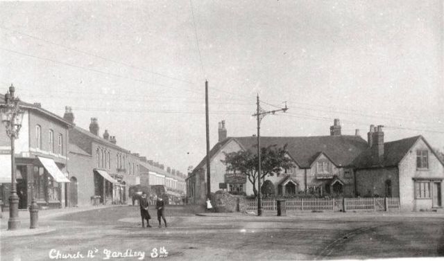
At one time the Outer Circle went straight on along the very narrow Church Road lined with tiny shops and terraced houses before it opened out into one of the familiar dual carriageways.
That has all changed and it seems that the power of the mighty supermarkets has re-planned this part of the bus route forever. Tesco has now opened a store to the right where the Tivoli Shopping Centre once stood and Church Road has been diverted around the car park, which has been built on what was parkland. The Tivoli Shopping Centre, named after the cinema, was demolished in 2011 to be replaced by the supermarket leaving the residential tower block above the new store.

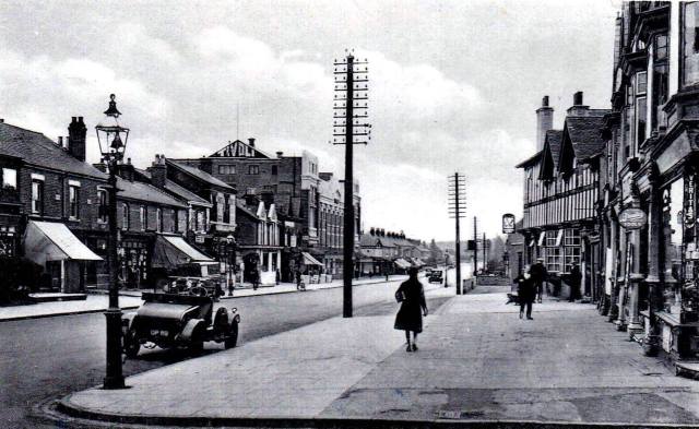
Yardley Road looking towards the Swan – early 20th century

Yardley Road looking towards the Swan – 2019

The row of shops between the Swan and Painters in the previous photograph. Demolished during the road widening.

The row of shops between the Swan and Painters in the previous photograph. Demolished during the road widening.
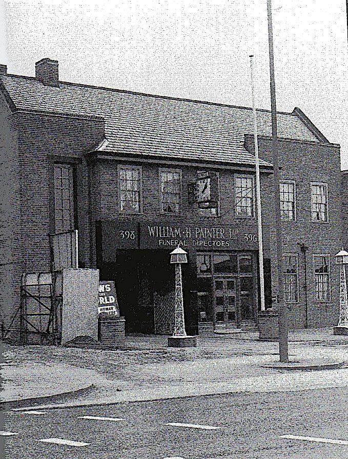
Painter’s new premises at the Swan after road widening – c1960s (they kept the clock!)

Painter’s – 2019 (it looks as if they had to get a new clock).

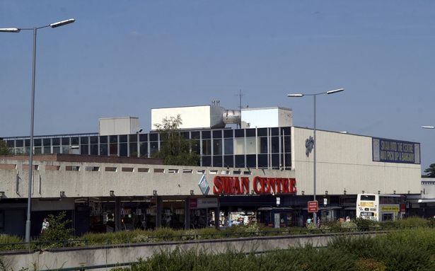
Approaching the Swan in 2019

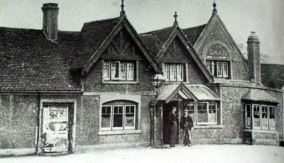
This is the oldest photograph I could find of The Swan at Yardley – c1870.
By 1890 The Swan has been spruced up a bit or rebuilt.

The Swan again in 1895.

This photograph was probably taken around 1898 when the previous Swan had evidently outlived its purpose and it was replaced by this Swan.

Around 1900 when it was possible to stand in the middle of the road at The Swan whilst a photographer took a photograph!
Loads of children in smocks being loaded onto a horse drawn carriage. Had they all been left outside with a bag of crisps and a bottle of Vimto? (Yes, I know that probably came later!) The Swan c1900.
The trams were running to The Swan by the time this photograph was taken. You can see the post supporting the Overhead Electrical Equipment on the left.
Spot the window cleaner! At The Swan.
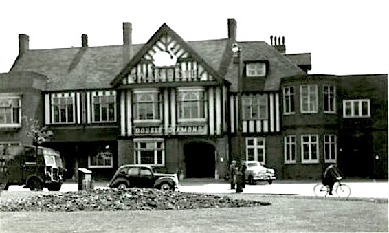
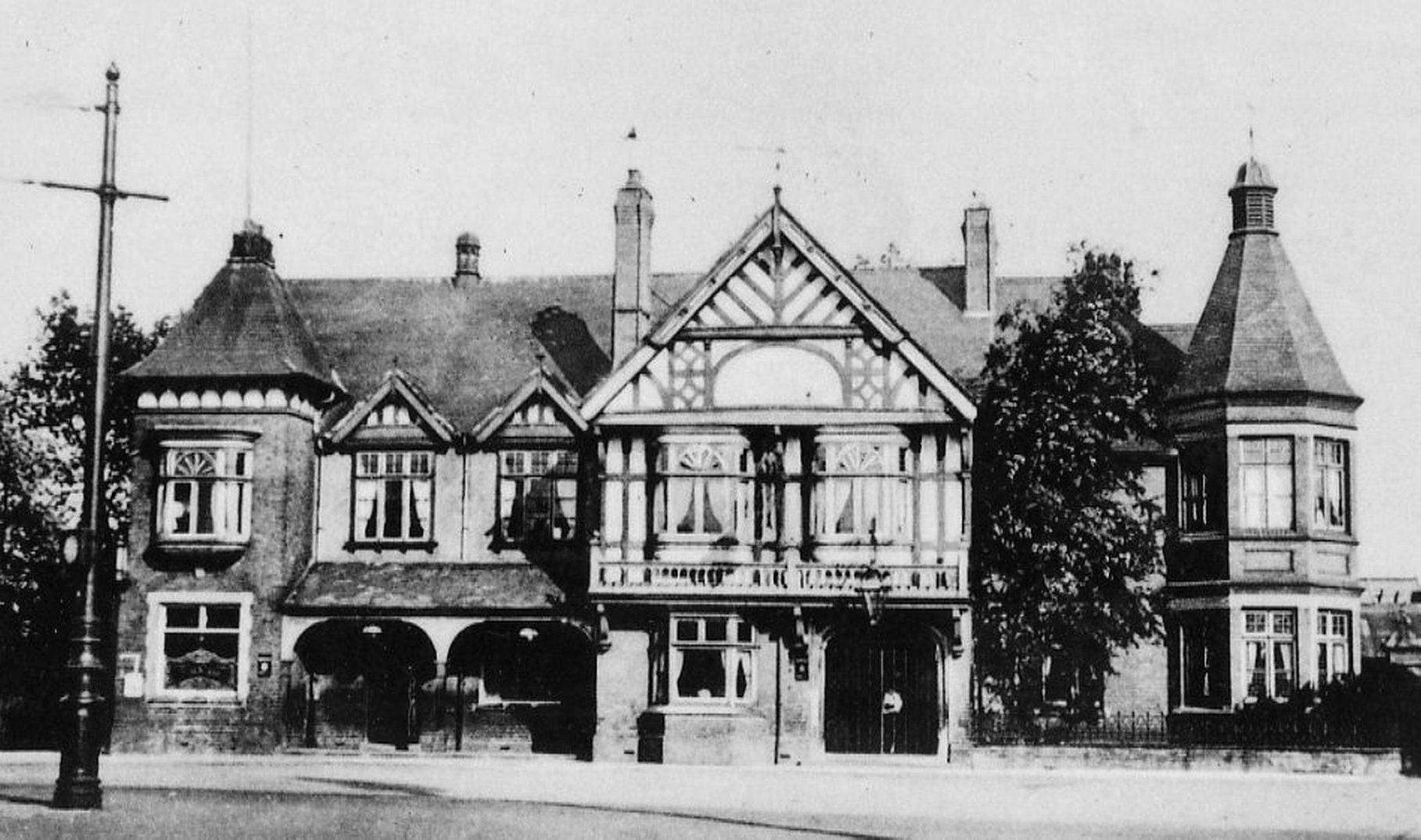
This photograph was probably taken in the 1950s, and compared with the previous photographs it can be seen that various bits had been altered making this Swan the one that most folk over a certain age will remember.

OH NO! What happened! Yes, in the late 1960s the Coventry Road was widened, the underpass was built, our well remembered Swan has gone and this was built to replace it. This was probably taken in 1968.
Here it is again in the 1970s.

This is the front cover of the commemorative booklet that was produced when the “New Swan” was opened in 1968. I’ll post the whole booklet one day so that one can see what was planned for the interior.

The final glimpse of the “New Swan”. It lasted about 30 years.

This is what replaced the Swan – an office block.

The view from Church Road looking towards The Swan roundabout in the 1950s. The Swan pub is on the left and the shop buildings on the left of Yardley Road were demolished when the junction was widened.

The view of the roundabout at “The Swan” looking along Church Road. The Swan pub is off to the right with the Coventry Road crossing the photograph. The photograph was taken after 1923 when road numbering was introduced – the road sign on the right shows A45. The tall building on the right was Hardings bakery which would have been demolished to make way for the Tivoli Shopping Centre in the 1960s.
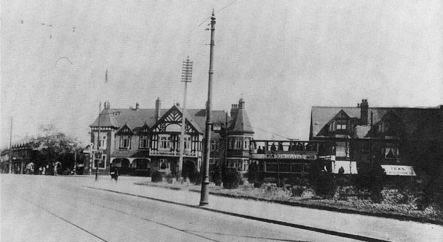
The Swan pub can be seen in this view from the Coventry Road, probably in the 1920s. The tram is in the turning circle at the terminus. The shops on the right are those mentioned at the end of Yardley Road in previous photographs
This is the Coventry Road looking towards Sheldon. The New Inn is on the right and The Swan is behind the camera. This photograph was taken after 1927 when the Tivoli Cinema opened.

Tivoli Cinema Yardley after closure on 1st July 1961
The 1950s again looking towards Sheldon. A Hillman Minx and an A40 Somerset in the foreground, a couple of buses, the bank building and The Swan, The Tivoli can be seen in the distance.
This is (I think) taken from just opposite The Swan (on the right) looking along the Coventry Road. This would have been before the Tivoli Cinema was built.
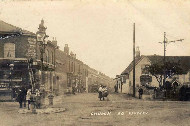
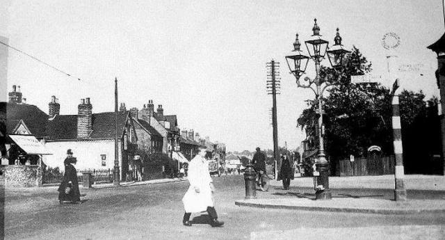
At a guess I’d say this was taken around 1910. There’s plenty going on. Ladies with a pram nattering in the middle of the road. Kids hanging about on the little roundabout. Some bloke up a ladder ….. nothing changes.
Looking in the same direction as the last photograph – along Church Road towards the Yew Tree.
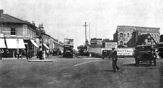
This photograph was taken from outside The Swan (on the right) with a bus on the No 11 route heading out of Church Road. However, This may not be an Outer Circle bus. The Outer Circle started in 1926, but it was created out of two routes, the 10 and the 11. the original 11 route ran between Erdington and Acocks Green. The buildings on the right corner of Church Road have been demolished and a building containing “Residential Flats & Lock-up Shops” is in the process of being built. This would be the bank building that we’ve seen in other photographs.
Church Road in 2008 before diversion around the Tesco car park and during the demolition of the Swan Shopping Centre on the right

Another view from the Coventry Road looking towards the “Swan” junction in the 1960s. The building under construction in the centre is the “New” Swan. The shops on the left (seen in previous photographs) have gone ready for the widening of the road, building the underpass and the construction of the office block that still stands on this corner of the junction.
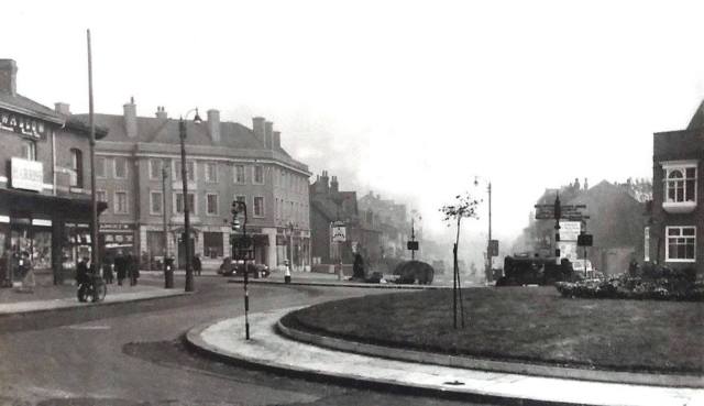
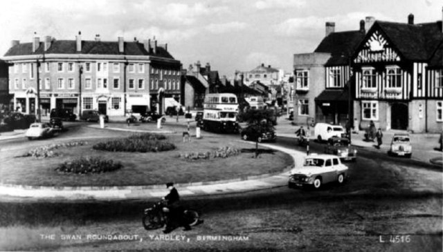
Another view of the the “Swan” roundabout looking towards Sheldon in the 1950s. The bank building on the corner of Church road replaced 19th century buildings that had stood in front of the bakery and it would be demolished when the underpass was built. The pub is just creeping into the photograph on the right.

Swan. The underpass is under construction, The Swan pub is about to be demolished. The Tivoli cinema will have gone to be replaced by the Tivoli Shopping centre and the flats had been built over the top. That is where this photograph was taken from.
The Swan Shopping Centre (the new name for the Tivoli Shopping Centre). Demolished to make way for the Tesco store.

The Swan Shopping Centre, about to be demolished (as if you couldn’t have guessed!)

The view from the Tivoli flats looking up Church Road towards the Yew Tree c1970s. The bus is making a U-turn at the end of the dual-carriageway. The Congregational Church is on the left.

Another view from the Tivoli flats looking up Church Road towards the Yew Tree flats c2019. The diverted Church Road is on the left around the car park that was built on parkland.

This photograph of the Swan was probably taken not long after 1934 when the Coventry Road trolleybus services started. Behind the bus shelter (similar to the one that was at Hall Green and since moved to Crich Tram Museum) is a No 11 bus.

So – there were trolleybuses on the Coventry Road. They also had them on the Nechells route, but they were replaced by diesel buses first. The route 94 terminated at the Swan where this turning circle was created at the end of Yardley Road. Those shops that have appeared in a few of these photographs are there and The Swan pub would be off to the left. This was taken in 1938 and some the trolleybus routes were extended to Arden Oak Road near the boundary and to the Rover Works in Solihull during the war.

So, more trolleybuses. Here’s one on the turning circle at the Swan, probably in the late 1940s.

And, another trolleybus approaching the Swan from the city in the late 1940s.
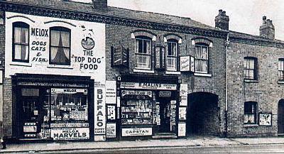
This is a couple of the shops in Church Road photographed in 1958. If you park your car at the supermarket you’ll be parking here!
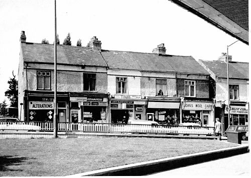
This is a few of the shops on the left side of Church Road, taken from the Tivoli (or Swan) Shopping Centre – probably in the 1970s.

Looking away from the direction that we are heading, so these buildings are on the right side of Church Road about 100 yards from the Swan junction. Numbers 16 & 14 Church Road, with the Mission Hall next door. Probably in the 1950s. The houses in the distance were in Victoria Terrace, built as a row of back-to-backs each with long gardens. They would have been demolished when the Tivoli Shopping Centre was built. The Swan was off to the right.

…. And Now! Finally an aerial view of the Swan with the supermarket car park and the realigned Church Road on the park. The offices that now stand on the site of The Swan is towards the bottom centre. The supermarket dominates the centre, and the Coventry Road crosses from left to right


